
Radio Aids to Marine Navigation 2024
Part 2: Facilities Information
2.1 Marine Communications and Traffic Services Centres
2.1.1 Halifax, Nova Scotia
MMSI: 003160016 Call Sign: VCS
Hours: H24
Radio Services in English and in French
All communications with Canadian Coast Guard Marine Communications and Traffic Services Centres are recorded.
For Radio Services call Halifax Coast Guard Radio.
For Vessel Traffic Services, call Halifax Traffic (Part 3.9.2) or Fundy Traffic (Part 3.9.1).
Coordinates
Mailing Address:
Fisheries and Oceans Canada
Canadian Coast Guard
Officer-in-Charge – MCTS Operations
Halifax MCTS Centre
10 Hudson Way
Dartmouth NS B2Y 3Z8
Telephone:
902-426-9750 or 902-426-9751 MCTS Operations
1-888-528-6444 MCTS Operations, Toll-Free
902-426-4956 ECAREG
Facsimile: 902-426-4483
Email:
hlxecareg1@innav.gc.ca ECAREG Canada
Supervisor.mcts-halifax@dfo-mpo.gc.ca
Halifax MCTS Centre VHF/DF Advisory Service
A VHF/DF Advisory Service is available to vessels within range of the receiver sites located at Cape Blomidon, Saint John, Tiverton, Yarmouth, Lockeport, Kingsburg, Sambro and Ecum Secum. Information concerning position, bearing and distance may be provided for use at the discretion of the user.
| Sites located at | Channels | Frequencies Transmit | Frequencies Receive | Remarks |
|---|---|---|---|---|
| Sambro 44°28’21"N 063°37’13"W |
Ch16 Ch26 Ch27 Ch70 |
- | - | VHF Direction Finding service is available. Ch26 and Ch27: Facilities are available for connecting ships directly to the commercial telephone system on shore. |
| - | 2182J3E 2514J3E 2582J3E |
- | ||
| Ecum Secum 44°57’53"N 062°08’56"W |
Ch16 Ch24 Ch26 Ch70 |
- | - | VHF Direction Finding service is available. Ch24 and Ch26: Facilities are available for connecting ships directly to the commercial telephone system on shore. |
| Kingsburg 44°16’32"N 064°17’15"W |
Ch16 Ch24 Ch26 Ch70 |
- | - | VHF Direction Finding service is available. Ch24, Ch26, 2118 and 2206: Facilities are available for connecting ships directly to the commercial telephone system on shore. |
| - | - | 2182 2118 2206 |
||
| Shannon Hill 44°41’03"N 063°36’35"W |
Ch12 Ch14 Ch16 Ch70 |
- | - | - |
| Chebucto Head 44°30’26"N 063°31’24"W |
Ch12 Ch14 Ch16 |
- | - | - |
| Yarmouth, N.S. 43°44'39"N 066°07'21"W (Chebogue) |
Ch14 Ch16 Ch24 Ch26 Ch70 |
- | - | VHF Direction Finding service is available. Ch24 and Ch26: Facilities are available for connecting ships directly to the commercial telephone system on shore. |
| - | 2182J3E 2538J3E 2582J3E |
- | ||
| Lockeport, N.S. 43°39'49"N 065°07'47"W |
Ch16 Ch24 Ch26 Ch70 |
- | - | VHF Direction Finding service is available. Ch24, Ch26, 2142 and 2206: Facilities are available for connecting ships directly to the commercial telephone system on shore. |
| - | - | 2182 2142 2206 |
||
| Saint John, N.B. 45°14'01"N 065°59'05"W (Red Head) |
Ch12 Ch14 Ch16 Ch24 Ch26 Ch70 Ch71 |
- | - | VHF Direction Finding service is available. Ch24 and Ch26: Facilities are available for connecting ships directly to the commercial telephone system on shore. |
| Cape Blomidon, N.S. 45°13'55"N 064°24'05"W |
Ch16 Ch24 Ch26 Ch70 Ch71 |
- | - | VHF Direction Finding service is available. Ch24 and Ch26: Facilities are available for connecting ships directly to the commercial telephone system on shore. |
| Grand Manan, N.B. 44°36'03"N 066°54'22"W |
Ch14 Ch16 Ch24 Ch26 Ch70 |
- | - | Ch24 and Ch26: Facilities are available for connecting ships directly to the commercial telephone system on shore. |
| Scotch Mountain, N.B. 45°45'48"N 065°47'36"W (NAD27) |
Ch16 Ch27 Ch70 |
- | - | Operational approximately mid-May to mid-November. Ch27: Facilities are available for connecting ships directly to the commercial telephone system on shore. |
| Letite, N.B. 45°02'20"N 066°53'33"W |
Ch14 | - | - | - |
| Tiverton, N.S. 44°23'40"N 066°13'36"W |
Ch12 Ch14 Ch16 Ch70 |
- | - | VHF Direction Finding service is available. |
| Time UTC | Site | Frequency or Channel | Contents |
|---|---|---|---|
| 01:40 | Yarmouth (Chebogue) |
2749J3E | Radiotelephony (English followed by French)
|
| 02:40 | Sambro | 2749J3E | Radiotelephony (English followed by French)
|
| 03:20 | Yarmouth (Chebogue) |
518F1B | NAVTEX: (U) English
|
| 03:30 | Yarmouth (Chebogue) |
490F1B | NAVTEX: (V) French
|
| 07:20 | Yarmouth (Chebogue) |
518F1B | NAVTEX: (U) English
|
| 07:30 | Yarmouth (Chebogue) |
490F1B | NAVTEX: (V) French
|
| 08:10 | Sambro | 2749J3E | Radiotelephony (English followed by French)
|
| 10:40 | Yarmouth (Chebogue) |
2749J3E | Radiotelephony (English followed by French)
|
| 11:20 | Yarmouth (Chebogue) |
518F1B | NAVTEX: (U) English
|
| 11:30 | Yarmouth (Chebogue) |
490F1B | NAVTEX: (V) French
|
| 15:20 | Yarmouth (Chebogue) |
518F1B | NAVTEX: (U) English
|
| 15:30 | Yarmouth (Chebogue) |
490F1B | NAVTEX: (V) French
|
| 15:40 | Sambro | 2749J3E | Radiotelephony (English followed by French)
|
| 16:40 | Yarmouth (Chebogue) |
2749J3E | Radiotelephony (English followed by French)
|
| 19:20 | Yarmouth (Chebogue) |
518F1B | NAVTEX: (U) English
|
| 19:30 | Yarmouth (Chebogue) |
490F1B | NAVTEX: (V) French
|
| 20:40 | Yarmouth (Chebogue) |
2749J3E | Radiotelephony (English followed by French)
|
| 21:20 | Sambro | 2749J3E | Radiotelephony (English followed by French)
|
| 23:20 | Yarmouth (Chebogue) |
518F1B | NAVTEX: (U) English
|
| 23:30 | Yarmouth (Chebogue) |
490F1B | NAVTEX: (V) French
|
| Continuous | Sambro | Ch21B (2021) | Radiotelephony (English followed by French)
|
| Lockeport | Ch21B (2021) | ||
| Ecum Secum | Ch83B (2083) | ||
| Continuous | Saint John, N.B. (Red Head) | Ch21B (2021) | Radiotelephony (English followed by French)
|
| Yarmouth (Chebogue) Cape Blomidon |
Ch83B (2083) |
2.1.2 Iqaluit, Nunavut
MMSI: 003160023 Call Sign: VFF
Hours: H24
Services in English and in French.
All communications with Canadian Coast Guard Marine Communications and Traffic Services Centres are recorded.
Open from approximately mid-May until mid-December.
Opening and closing will be announced by Navigational Warning.
For Radio Services call Iqaluit Coast Guard Radio.
Marine Safety Information can also be received via email upon request.
Coordinates
Mailing Address:
Fisheries and Oceans Canada
Canadian Coast Guard
Officer-in-Charge – MCTS Operations
Iqaluit MCTS Centre/NORDREG CANADA
1063 Niuraivik Lane
Iqaluit NU X0A 3H0
Telephone:
867-979-5269 MCTS Operations (East)
867-979-0310 MCTS Operations (West)
867-979-5724 NORDREG Operations
Facsimile: 867-979-4264 MCTS/NORDREG Operations
Telex (Telefax): 063-15529 NORDREG CDA
Email:
IQANORDREG@innav.gc.ca (operations)
NAVWARN.MCTSIqaluit@innav.gc.ca
| Sites located at | Channels | Frequencies Transmit |
Frequencies Receive |
Remarks |
|---|---|---|---|---|
| Iqaluit 63°43'52"N 068°32'32"W |
Ch16 Ch26 |
- | - | This site is operational approximately mid-May to mid-December. |
403 603 812 1201 |
2182J3E 2582J3E 4363J3E 6507J3E 8752J3E 13077J3E |
2182 2206 4071 6206 8228 12230 |
||
| - | 4207.5F1B 6312.0F1B 8414.5F1B 12577.0F1B 16804.5F1B |
4207.5 6312.0 8414.5 12577.0 16804.5 |
||
| - | 4177.5F1B 6268F1B 8376.5F1B 12520F1B 16695F1B |
4177.5 6268 8376.5 12520 16695 |
||
1621 |
4125J3E 6215J3E 8291J3E 12290J3E 16420J3E |
4125 6215 8291 12290 16420 |
||
| Churchill 58°46'29"N 094°11'22"W |
Ch16 Ch26 |
- | - | This site is operational approximately mid-July to late October. |
| Killinek 60°25'27"N 064°50'30"W |
403 |
2182J3E 2514J3E 2582J3E 4363J3E |
2182 2118 2206 4071 |
This site is operational approximately early July to mid-December. |
| Coral Harbour 64°09'01"N 083°22'22"W |
403 603 812 1201 |
2182J3E 2514J3E 2582J3E 4363J3E 6507J3E 8752J3E 13077J3E |
2182 2118 2206 4071 6206 8228 12230 |
This site is operational approximately early July to late October. |
| Resolute 74°44'47"N 095°00'11"W |
Ch16 Ch26 |
- | - | This site is operational approximately mid-July to late October. |
403 812 |
2182J3E 2582J3E 4363J3E 8752J3E |
2182 2206 4071 8228 |
||
| - | - | 4207.5 6312.0 8414.5 12577.0 16804.5 |
||
| - | - | 4177.5 6268 8376.5 12520 16695 |
||
| - | - | 4125 6215 8291 12290 16420 |
||
| Hay River 60°50'27"N 115°46'12"W |
403 601 826 |
4363J3E 5803J3E 6218.6J3E 6501J3E 8794J3E |
4071 5803 6218.6 6200 8270 |
This site is operational approximately mid-May to late October. |
| Yellowknife 62°25'45"N 114°24'44"W |
Ch16 Ch85 |
- | - | This site is operational approximately mid-May to late October. |
| Enterprise 60°36'30"N 116°13'13"W |
Ch16 Ch26 |
- | - | This site is operational approximately mid-May to late October. |
| Inuvik 68°19'30"N 133°35'47"W |
403 601 826 1201 |
2182J3E 2558J3E 4363J3E 5803J3E 6218.6J3E 6501J3E 8794J3E 13077J3E |
2182 2142 4071 5803 6218.6 6200 8270 12230 |
This site is operational approximately mid-May to late October. |
| Parson’s Lake 68°53'38"N 133°56'31"W |
Ch16 Ch26 |
- | - | This site is operational approximately mid-May to late October. |
| Cambridge Bay 69°06'53"N 105°01'11"W |
Ch16 Ch26 |
- | - | This site is operational approximately early July to mid-October. |
403 601 826 |
2182J3E 2558J3E 4363J3E 5803J3E 6501J3E 8794J3E |
2182 2142 4071 5803 6200 8270 |
| Time UTC | Site | Frequency or Channel | Contents |
|---|---|---|---|
| 01:10 | Coral Harbour | 2514J3E | Radiotelephony
|
| Coral Harbour | 6507J3E | ||
| 01:15 | Inuvik | 6218.6J3E | Radiotelephony
|
| Hay River | 4363J3E | ||
| Parson’s Lake and Enterprise | Ch26 | ||
| Yellowknife | Ch85 | ||
| 02:35 | Cambridge Bay | 4363J3E | Radiotelephony
|
| Inuvik | 6218.6J3E | ||
| 03:00 | Iqaluit | 490F1B | NAVTEX: (S) French
|
| 03:10 | Iqaluit | 518F1B | NAVTEX: (T) English
|
| 03:30 | Iqaluit | 8416.5F1B | HF NBDP
|
| 07:00 | Iqaluit | 490F1B | NAVTEX: (S) French
|
| 07:10 | Iqaluit | 518F1B | NAVTEX: (T) English
|
| 11:00 | Iqaluit | 490F1B | NAVTEX: (S) French
|
| 11:10 | Iqaluit | 518F1B | NAVTEX: (T) English
|
| 12:40 | Resolute | 2582J3E | Radiotelephony
|
| Resolute | 4363J3E | ||
| 13:15 | Inuvik | 6218.6J3E | Radiotelephony
|
| Hay River | 4363J3E | ||
| Parson’s Lake and Enterprise | Ch26 | ||
| Yellowknife | Ch85 | ||
| 13:20 | Coral Harbour | 2514J3E | Radiotelephony
|
| 14:10 | Killinek | 2514J3E | Radiotelephony
|
| Iqaluit | 2582J3E | ||
| Iqaluit | 4363J3E | ||
| 14:35 | Cambridge Bay | 2558J3E | Radiotelephony
|
| Inuvik | 6218.6J3E | ||
| 15:00 | Iqaluit | 490F1B | NAVTEX: (S) French
|
| 15:10 | Iqaluit | 518F1B | NAVTEX: (T) English
|
| 15:30 | Iqaluit | 8416.5F1B | HF NBDP
|
| 17:05 | Cambridge Bay | 4363J3E | Radiotelephony
|
| Inuvik | 6218.6J3E | ||
| Coral Harbour/Killinek | 2514J3E | ||
| Iqaluit/Resolute | 2582J3E | ||
| 19:00 | Iqaluit | 490F1B | NAVTEX: (S) French
|
| 19:10 | Iqaluit | 518F1B | NAVTEX: (T) English
|
| 22:35 | Killinek | 2514J3E | Radiotelephony
|
| Iqaluit | 2582J3E | ||
| 23:00 | Iqaluit | 490F1B | NAVTEX: (S) French
|
| 23:10 | Iqaluit | 518F1B | NAVTEX: (T) English
|
| 23:10 | Resolute | 2582J3E | Radiotelephony
|
2.1.3 Labrador (Happy Valley-Goose Bay), Newfoundland and Labrador
MMSI: 003160022 Call Sign: VOK
Hours: H24
Services in English only.
All communications with Canadian Coast Guard Marine Communications and Traffic Services Centres are recorded.
For Radio Services, call Labrador Coast Guard Radio.
For Vessel Traffic Services, call Belle Isle Traffic (Part 3.9.9).
Coordinates
Mailing Address:
Fisheries and Oceans Canada
Canadian Coast Guard
Officer-in-Charge – MCTS Operations
Labrador MCTS Centre
P.O. Box 720 Station C
Happy Valley-Goose Bay, NL A0P 1C0
Telephone:
709-896-2252 MCTS Operations
709-896-0277/0278 Commercial Public Correspondence Service
Facsimile: 709-896-8455
Email: Safety.Labrador@innav.gc.ca
| Sites located at | Channels | Frequencies Transmit |
Frequencies Receive |
Remarks |
|---|---|---|---|---|
| Cartwright 53°42'30"N 057°01'17"W |
407 |
2182J3E 2514J3E 2538J3E 2582J3E 4375.0J3E |
2182 2118 2142 2206 4083.0 |
407, 2118, 2142, 2206 and 4083.0: Facilities are available for connecting ships directly to the commercial telephone system on shore. |
| Hopedale 55°27'24"N 060°12'30"W |
407 605 Ch16 Ch26 Ch70 |
2182J3E 2514J3E 2538J3E 2582J3E 4375.0J3E 6513J3E |
2182 2118 2142 2206 4083.0 6212 |
407, 605, Ch26, 2118, 2142, 2206, 4083.0 and 6212: Facilities are available for connecting ships directly to the commercial telephone system on shore. |
| Cartwright 53°43'38"N 056°58'06"W |
Ch16 Ch24 Ch70 |
- | - | Ch24: Facilities are available for connecting ships directly to the commercial telephone system on shore. |
| Happy Valley-Goose Bay 53°18'12"N 060°31'27"W |
Ch16 Ch26 Ch70 |
- | - | Ch26: Facilities are available for connecting ships directly to the commercial telephone system on shore. |
| Nain 56°32'49"N 061°42'49"W |
Ch16 Ch24 Ch70 |
- | - | Ch24: Facilities are available for connecting ships directly to the commercial telephone system on shore. |
| Pistolet Bay 51°30'00"N 055°49'26"W |
- | 2182J3E 2514J3E 2582J3E |
2182 2118 2206 |
2118 and 2206: Facilities are available for connecting ships directly to the commercial telephone system on shore. |
| Comfort Cove 49°16'26"N 054°52'32"W |
Ch16 Ch26 Ch70 |
- | - | Ch26: Facilities are available for connecting ships directly to the commercial telephone system on shore. |
| Twillingate 49°41'10"N 054°48'00"W |
Ch16 Ch24 Ch70 |
- | - | Ch24: Facilities are available for connecting ships directly to the commercial telephone system on shore. |
| L’Anse aux Meadows 51°34'20"N 055°29'27"W |
Ch14 Ch16 Ch24 Ch70 |
- | - | Ch24: Facilities are available for connecting ships directly to the commercial telephone system on shore. |
| Conche 50°53'41"N 055°53'03"W |
Ch16 Ch26 Ch70 |
- | - | Ch26: Facilities are available for connecting ships directly to the commercial telephone system on shore. |
| Fox Harbour 52°22'10"N 055°39'42"W |
Ch16 Ch26 Ch70 |
- | - | Ch26: Facilities are available for connecting ships directly to the commercial telephone system on shore. |
| Time UTC | Site | Frequency or Channel | Contents |
|---|---|---|---|
| 01:07 | Pistolet Bay | 2598J3E | Radiotelephony
|
| 01:37 | Cartwright | 2598J3E | Radiotelephony
|
| Hopedale | 2598J3E | ||
| 03:50 | Cartwright | 518F1B | NAVTEX: (X)
|
| 07:50 | Cartwright | 518F1B | NAVTEX: (X)
|
| 09:07 | Pistolet Bay | 2598J3E | Radiotelephony
|
| 10:07 | Cartwright | 2598J3E | Radiotelephony
|
| Hopedale | |||
| 11:07 | Cartwright | 2598J3E | Radiotelephony
|
| Hopedale | |||
| 11:50 | Cartwright | 5181F1B | NAVTEX: (X)
|
| 12:37 | Pistolet Bay | 2598J3E | Radiotelephony
|
| 13:37 | Pistolet Bay | 2598J3E | Radiotelephony
|
| 14:37 | Cartwright | 2598J3E | Radiotelephony
|
| Hopedale | 2598J3E | ||
| 15:50 | Cartwright | 518F1B | NAVTEX: (X)
|
| 19:07 | Pistolet Bay | 2598J3E | Radiotelephony
|
| 19:37 | Pistolet Bay | 2598J3E | Radiotelephony
|
| 19:50 | Cartwright | 518F1B | NAVTEX: (X)
|
| 20:37 | Cartwright | 2598J3E | Radiotelephony
|
| Hopedale | |||
| 23:07 | Cartwright | 2598J3E | Radiotelephony
|
| Hopedale | 2598J3E | ||
| 23:50 | Cartwright | 518F1B | NAVTEX: (X)
|
| Continuous Labrador North | Cartwright Nain | Ch83B (2083) | Radiotelephony
|
| Happy Valley-Goose Bay Hopedale | Ch21B (2021) | ||
| Continuous Labrador South | Conche Fox Harbour Comfort Cove |
Ch21B (2021) | Radiotelephony
|
| L’Anse aux Meadows Twillingate |
Ch83B (2083) |
2.1.4 Les Escoumins, Québec
MMSI: 003160026 Call Sign: VCF
Hours: H24
Services in English and in French.
All communications with Canadian Coast Guard Marine Communications and Traffic Services Centres are recorded.
For Radio Services, call Les Escoumins Coast Guard Radio.
For Vessel Traffic Services, call Escoumins Traffic (Part 3.9.7).
Coordinates
Mailing Address:
Fisheries and Oceans Canada
Canadian Coast Guard
Officer-in-Charge – MCTS Operations
Les Escoumins MCTS Centre
35 Otis Street
Les Escoumins QC G0T 1K0
Telephone:
418-233-2194 MCTS Operations
418-233-3451 Coast Guard Radio
418-233-3556 Public Correspondence Service
418-233-3483 ECAREG Canada and NORDREG Canada
Email:
safety.escoumins@innav.gc.ca (Coast Guard Radio)
ecareg.escoumins@innav.gc.ca (ECAREG Canada)
iqanordreg@innav.gc.ca (NORDREG Canada – late December to mid-May)
Les Escoumins MCTS Centre VHF Direction Finding Advisory Service:
A VHF/DF advisory service is available to vessels in difficulty within range of the receiver sites located at Rivière-au-Renard, Cap-aux-Meules, Havre St-Pierre, Natashquan, Newport, Pointe Heath, Mont-Louis, Lac Daigle (Sept-Îles) and Grosses-Roches. Information concerning position, bearing and distance may be provided for use at the discretion of the user.
| Sites located at | Channels | Frequencies Transmit |
Frequencies Receive |
Remarks |
|---|---|---|---|---|
| Rivière-au-Renard 49°00'25"N 064°24'00"W |
Ch16 Ch27 |
- | - | VHF Direction Finding service is available. Ch27: Facilities are available for connecting ships directly to the commercial telephone system on shore. |
| - | - | - | ||
| Cap-aux-Meules 47°23'14"N 061°51'40"W |
Ch16 Ch27 Ch70 |
- | - | VHF Direction Finding service is available. Ch27 and 2118: Facilities are available for connecting ships directly to the commercial telephone system on shore. |
| - | - | 2182 2118 2206 |
||
| La Vernière 47°21'28"N 061°55'30"W |
- | 2182J3E 2514J3E 2582J3E |
- | - |
| Havre St-Pierre 50°16'18"N 063°40'45"W |
Ch16 Ch26 Ch70 |
- | - | VHF Direction Finding service is available. Ch26: Facilities are available for connecting ships directly to the commercial telephone system on shore. |
| Natashquan 50°09'06"N 061°47'42"W |
Ch16 Ch26 Ch70 |
- | - | VHF Direction Finding service is available. Ch26: Facilities are available for connecting ships directly to the commercial telephone system on shore. |
| - | 2182J3E 2582J3E |
2182 2206 |
||
| Harrington Harbour 50°30'01"N 059°29'17"W |
Ch16 Ch26 Ch70 |
- | - | Ch26: Facilities are available for connecting ships directly to the commercial telephone system on shore. |
| La Romaine 50°12'56"N 060°41'03"W |
Ch16 Ch26 Ch70 |
- | - | Ch26: Facilities are available for connecting ships directly to the commercial telephone system on shore. |
| Forillon 48°50'01"N 064°15'24"W |
Ch16 Ch70 Ch85 |
- | - | Ch85: Facilities are available for connecting ships directly to the commercial telephone system on shore. |
| Carleton 48°08'28"N 066°06'32"W |
Ch16 Ch70 Ch85 |
- | - | Ch85: Facilities are available for connecting ships directly to the commercial telephone system on shore. |
| Newport 48°13'24"N 064°47'33"W |
Ch16 Ch70 Ch84 |
- | - | VHF Direction Finding service is available. Ch84: Facilities are available for connecting ships directly to the commercial telephone system on shore. |
| Pointe Heath 49°05'05"N 061°42'09"W |
Ch16 Ch70 Ch84 |
- | - | VHF Direction Finding service is available. Ch84: Facilities are available for connecting ships directly to the commercial telephone system on shore. |
| Mont-Louis 49°12'48"N 065°46'25"W |
Ch14 Ch16 Ch26 Ch70 |
- | - | VHF Direction Finding service is available. Ch26: Facilities are available for connecting ships directly to the commercial telephone system on shore. |
| Lac Daigle 50°17'25"N 066°18'36"W |
Ch14 Ch16 Ch26 Ch70 |
- | - | VHF Direction Finding service is available. Ch26: Facilities are available for connecting ships directly to the commercial telephone system on shore. |
| Grosses-Roches 48°54'50"N 067°06'37"W |
Ch14 Ch16 Ch70 Ch84 |
- | - | VHF Direction Finding service is available. Ch84: Facilities are available for connecting ships directly to the commercial telephone system on shore. |
| Mont-Joli 48°36'25"N 068°13'33"W |
Ch9 Ch16 Ch26 Ch70 |
- | - | Ch26: Facilities are available for connecting ships directly to the commercial telephone system on shore. |
| Les Escoumins 48°19'04"N 069°25'14"W |
Ch9 Ch16 Ch24 Ch70 |
- | - | Ch24: Facilities are available for connecting ships directly to the commercial telephone system on shore. |
| Rivière-du-Loup 47°45'35"N 069°36'19"W |
Ch9 Ch16 Ch26 |
- | - | Ch26: Facilities are available for connecting ships directly to the commercial telephone system on shore. |
| Sacré-Cœur 48°12'50"N 069°52'14"W |
Ch9 Ch16 Ch26 Ch70 |
- | - | Ch26: Facilities are available for connecting ships directly to the commercial telephone system on shore. |
| Cap à l’Est 48°22'58"N 070°41'12"W |
Ch9 Ch16 Ch26 Ch70 |
- | - | Ch26: Facilities are available for connecting ships directly to the commercial telephone system on shore. |
| Time UTC | Site | Frequency or Channel | Contents |
|---|---|---|---|
| 00:20 | Moisie | 518F1B | NAVTEX: (C) English
|
| 00:30 | Moisie | 490F1B | NAVTEX: (D) French
|
| 04:20 | Moisie | 518F1B | NAVTEX: (C) English
|
| 04:30 | Moisie | 490F1B | NAVTEX: (D) French
|
| 04:37 | Natashquan La Vernière |
2598J3E 2749J3E |
Radiotelephony (French followed by English)
|
| 08:20 | Moisie | 518F1B | NAVTEX: (C) English
|
| 08:30 | Moisie | 490F1B | NAVTEX: (D) French
|
| 08:47 | Natashquan La Vernière |
2598J3E 2749J3E |
Radiotelephony (French followed by English)
|
| 09:37 | Natashquan La Vernière |
2598J3E 2749J3E |
Radiotelephony (French followed by English)
|
| 12:20 | Moisie | 518F1B | NAVTEX: (C) English
|
| 12:30 | Moisie | 490F1B | NAVTEX: (D) French
|
| 14:07 | Natashquan La Vernière |
2598J3E 2749J3E |
Radiotelephony (French followed by English)
|
| 16:20 | Moisie | 518F1B | NAVTEX: (C) English
|
| 16:30 | Moisie | 490F1B | NAVTEX: (D) French
|
| 17:37 | Natashquan La Vernière |
2598J3E 2749J3E |
Radiotelephony (French followed by English)
|
| 20:20 | Moisie | 518F1B | NAVTEX: (C) English
|
| 20:30 | Moisie | 490F1B | NAVTEX: (D) French
|
| 23:17 | Natashquan La Vernière |
2598J3E 2749J3E |
Radiotelephony (French followed by English)
|
| Continuous | Forillon Carleton Natashquan Cap-aux-Meules |
Ch21B (2021) | Radiotelephony (French followed by English)
|
| Pointe Heath Harrington Harbour |
Ch25B(2025) | ||
| Newport Havre St-Pierre La Romaine |
Ch83B (2083) | ||
| Continuous | Lac Daigle Grosses-Roches Cap à l’Est |
Ch21B (2021) | Radiotelephony (French followed by English)
|
| Mont-Louis Mont-Joli Sacré-Cœur |
Ch83B (2083) |
Note: Hourly weather observations for certain specific locations, technical marine synopsis, other weather forecast areas and MAFOR codes are available upon request.
2.1.5 Placentia, Newfoundland and Labrador
MMSI: 003160019 Call Sign: VCP
Hours: H24
Services in English only.
All communications with Canadian Coast Guard Marine Communications and Traffic Services Centres are recorded.
For Radio Services, call Placentia Coast Guard Radio.
For Vessel Traffic Services, call Placentia Traffic (Part 3.9.4) or St. John’s Traffic (Part 3.9.6).
Coordinates
Mailing Address:
Fisheries and Oceans Canada
Canadian Coast Guard
Officer-in-Charge – MCTS Operations
Placentia MCTS Centre
P.O. Box 389
Placentia NL A0B 2Y0
Telephone:
709-227-2181/2182 MCTS Operations
1-844-592-2770 MCTS Operations Toll-Free
709-227-1027 Commercial Public Correspondence Service
709-227-5731 Officer-in-Charge
Facsimile: 709-227-5637
Email: Safety.Placentia@innav.gc.ca
| Sites located at | Channel | Frequencies Transmit | Frequencies Receive | Remarks |
|---|---|---|---|---|
| St. Lawrence 46°55′09″N 055°22′45″W |
Ch16 Ch26 Ch70 |
- | - | Ch26: Facilities are available for connecting ships directly to the commercial telephone system on shore. |
| St. Lawrence 46°55′06″N 055°22′45″W |
- | 2182J3E 2514J3E 2582J3E |
2182 2118 2206 |
2118 and 2206: Facilities are available for connecting ships directly to the commercial telephone system on shore. |
| Cape Pine 46°37′00″N 053°31′58″W |
Ch16 Ch24 Ch70 |
- | - | Ch24: Facilities are available for connecting ships directly to the commercial telephone system on shore. |
| Fortune Head 47°04′02″N 055°50′52″W |
Ch16 Ch24 Ch70 |
- | - | Ch24: Facilities are available for connecting ships directly to the commercial telephone system on shore. |
| Hermitage 47°33′34″N 055°56′19″W |
Ch16 Ch70 Ch85 |
- | - | - |
| Bay L'Argent 47°32′00″N 054°51′46″W |
Ch16 Ch27 Ch70 |
- | - | - |
| Arnold's Cove 47°46′23″N 053°59′59″W |
Ch12 Ch16 Ch70 |
- | - | - |
| Freshwater 47°15′44″N 053°59′03″W |
Ch12 Ch14 Ch16 Ch70 Ch85 |
- | - | - |
| Cuslett 46°58′28″N 054°09′15″W |
Ch14 Ch16 Ch70 |
- | - | - |
| St. John's 47°36′40″N 052°40′01″W |
Ch11 Ch12 Ch16 Ch26 Ch70 |
- | - | Ch26, 2118 and 2206: Facilities are available for connecting ships directly to the commercial telephone system on shore. |
| - | 2182J3E 2514J3E 2538J3E 2582J3E |
2182 2118 2142 2206 |
||
| Cape Bonavista 48°41′48″N 053°05′18″W |
Ch16 Ch26 Ch70 |
- | - | Ch26: Facilities are available for connecting ships directly to the commercial telephone system on shore. |
| Victoria 47°49′54″N 053°18′05″W |
Ch16 Ch24 Ch70 |
- | - | Ch24: Facilities are available for connecting ships directly to the commercial telephone system on shore. |
| Lumsden 49°17′14″N 053°35′05″W |
Ch16 Ch26 Ch70 |
- | - | Ch26: Facilities are available for connecting ships directly to the commercial telephone system on shore. |
| Time UTC | Site | Frequency or Channel | Contents |
|---|---|---|---|
| 00:07 | St. John's | 2598J3E | Radiotelephony
|
| 00:48 | St. Lawrence | 2598J3E | Radiotelephony
|
| 02:20 | Robin Hood Bay | 518F1B | NAVTEX: (O)
|
| 06:20 | Robin Hood Bay | 518F1B | NAVTEX: (O)
|
| 07:37 | St. Lawrence | 2598J3E | Radiotelephony
|
| 08:37 | St. John's | 2598J3E | Radiotelephony
|
| 10:20 | Robin Hood Bay | 518F1B | NAVTEX: (O)
|
| 11:37 | St. Lawrence | 2598J3E | Radiotelephony
|
| 13:07 | St. John's | 2598J3E | Radiotelephony
|
| 14:20 | Robin Hood Bay | 518F1B | NAVTEX: (O)
|
| 16:07 | St. Lawrence | 2598J3E | Radiotelephony
|
| 16:37 | St. John's | 2598J3E | Radiotelephony
|
| 18:07 | St. Lawrence | 2598J3E | Radiotelephony
|
| 18:20 | Robin Hood Bay | 518F1B | NAVTEX: (O)
|
| 20:07 | St. John's | 2598J3E | Radiotelephony
|
| 21:37 | St. Lawrence | 2598J3E | Radiotelephony
|
| 22:07 | St. John's | 2598J3E | Radiotelephony
|
| 22:20 | Robin Hood Bay | 518F1B | NAVTEX: (O)
|
| Continuous Placentia North |
St. John's Cape Bonavista |
Ch21B (2021) | Radiotelephony
|
| Victoria | Ch83B (2083) | ||
| Lumsden | Ch28B (2028) | ||
| Continuous Placentia South |
St. Lawrence Bay L'Argent |
Ch21B (2021) | Radiotelephony
|
| Freshwater | Ch23B (2023) | ||
| Hermitage | Ch28B (2028) | ||
| Cape Pine Fortune Head |
Ch83B (2083) |
2.1.6 Port aux Basques, Newfoundland and Labrador
MMSI: 003160018 Call Sign: VOJ
Hours: H24
Radio Services in English and in French.
All communications with Canadian Coast Guard Marine Communications and Traffic Services Centres are recorded.
For Radio Services call Port aux Basques Coast Guard Radio.
For Vessel Traffic Services, call Port aux Basques Traffic (Part 3.9.5).
Coordinates
Mailing Address:
Fisheries and Oceans Canada
Canadian Coast Guard
Officer-in-Charge – MCTS Operations
Port aux Basques MCTS Centre
P.O. Box 99
Port aux Basques NL A0M 1C0
Telephone:
709-695-2167 MCTS Operations
709-695-2886 Commercial Public Correspondence Service
Facsimile: 709-695-7784
Email:
safety.portauxbasques@innav.gc.ca
NAVWARN.MCTSPortAuxBasques@innav.gc.ca
| Sites located at | Channel | Frequencies Transmit | Frequencies Receive | Remarks |
|---|---|---|---|---|
| Table Mountain 47°41′14″N 059°16′26″W |
Ch11 Ch12 Ch16 Ch27 Ch70 |
- | - | Ch27: Facilities are available for connecting ships directly to the commercial telephone system on shore. |
| Stephenville 48°33′17″N 058°45′32″W |
- | 2182J3E 2514J3E 2582J3E |
2182 2118 2206 |
2118 and 2206: Facilities are available for connecting ships directly to the commercial telephone system on shore. |
| Pine Tree 48°35′20″N 058°39′54″W |
Ch16 Ch24 Ch70 |
- | - | Ch24: Facilities are available for connecting ships directly to the commercial telephone system on shore. |
| Bonne Bay 49°36′10″N 057°57′28″W |
Ch16 Ch24 Ch70 |
- | - | Ch24: Facilities are available for connecting ships directly to the commercial telephone system on shore. |
| Mount Moriah 48°58′07″N 058°02′49″W |
Ch16 Ch24 Ch70 |
- | - | Ch24: Facilities are available for connecting ships directly to the commercial telephone system on shore. |
| Ramea Island 47°30′45″N 057°24′31″W |
Ch16 Ch26 Ch70 |
- | - | Ch26: Facilities are available for connecting ships directly to the commercial telephone system on shore. |
| Pointe Riche 50°41′59″N 057°24′19″W |
Ch16 Ch26 Ch70 |
- | - | Ch26: Facilities are available for connecting ships directly to the commercial telephone system on shore. |
| Time UTC | Site | Frequency or Channel | Contents |
|---|---|---|---|
| 02:07 | Stephenville | 2598J3E | Radiotelephony (English followed by French)
|
| 08:07 | Stephenville | 2598J3E | Radiotelephony (English followed by French)
|
| 12:07 | Stephenville | 2598J3E | Radiotelephony (English followed by French)
|
| 15:07 | Stephenville | 2598J3E | Radiotelephony (English followed by French)
|
| 18:37 | Stephenville | 2598J3E | Radiotelephony (English followed by French)
|
| 21:07 | Stephenville | 2598J3E | Radiotelephony (English followed by French)
|
| Continuous | Ramea Island Pointe Riche |
Ch21B (2021) | Radiotelephony (English)
|
| Table Mountain Pine Tree Mount Moriah |
Ch28B (2028) | ||
| Bonne Bay | Ch83B (2083) | ||
| Continuous | Pointe Riche | Ch23B (2023) | Radiotelephony (French)
|
| Bonne Bay | Ch21B (2021) | ||
| Pine Tree Mount Moriah |
Ch83B (2083) |
2.1.7 Prescott, Ontario
MMSI: 003160029 Call Sign: VBR
Hours: H24
Services in English and in French
All communications with Canadian Coast Guard Marine Communications and Traffic Services Centres are recorded.
For Radio Services, call Prescott Coast Guard Radio.
Coordinates
Mailing Address:
Fisheries and Oceans Canada
Canadian Coast Guard
Officer-in-Charge – MCTS Operations
Prescott MCTS Centre
P.O. Box 1000
401 King Street West
Prescott ON K0E 1T0
Telephone:
613-925-4471 MCTS Operations
613-925-0666 NAVWARN Desk / NAVAREA XVII and XVIII
Facsimile: 613-925-4519
Email:
Safety.Prescott@innav.gc.ca Prescott MCTS
navarea17.18@innav.gc.ca Navarea XVII and XVIII
NAVWARN.MCTSPrescott@innav.gc.ca
| Sites located at | Channel | Frequencies Transmit | Frequencies Receive | Remarks |
|---|---|---|---|---|
| Cornwall 45°01′06″N 074°43′47″W |
Ch16 Ch70 Ch85 |
- | - | Operational March 15 to December 31. |
| Cardinal 44°47′17″N 075°25′19″W |
Ch16 Ch26 Ch27 Ch70 |
- | - | Operational March 15 to December 31. |
| Gananoque 44°23′59″N 075°58′23″W |
Ch16 Ch85 |
- | - | Operational March 15 to December 31. |
| Kingston 44°15′46″N 076°40′39″W |
Ch16 Ch24 Ch26 Ch70 |
- | - | - |
| Cobourg 44°03′59″N 078°12′41″W |
Ch16 Ch27 Ch70 Ch85 |
- | - | - |
| Trafalgar 43°29′41″N 079°43′48″W |
Ch16 Ch24 Ch70 |
- | - | - |
| Fonthill 43°03′11″N 079°18′42″W |
Ch16 Ch26 Ch27 Ch70 |
- | - | - |
| Orillia 44°34′40″N 079°17′40″W |
Ch16 Ch26 Ch70 |
- | - | - |
| Sites located at | Channels | Frequencies Transmit |
Frequencies Receive |
Remarks |
|---|---|---|---|---|
| Beaver Creek 51°23'21"N 096°54'25"W |
Ch16 Ch26 |
- | - | Operational May 15 to October 31. |
| Fraserwood 50°34'47"N 097°13'56"W |
Ch16 Ch19 |
- | - | Operational May 15 to October 31. |
| Jackhead 51°53'20"N 097°19'01"W |
Ch16 Ch26 |
- | - | Operational May 15 to October 31. |
| Long Point 52°55'33"N 098°58'10"W |
Ch16 Ch26 |
- | - | Operational May 15 to October 31. |
| Time UTC | Site | Frequency or Channel | Contents |
|---|---|---|---|
| 01:10 | Ferndale | 518F1B | NAVTEX: (H)
|
| 05:10 | Ferndale | 518F1B | NAVTEX: (H)
|
| 09:10 | Ferndale | 518F1B | NAVTEX: (H)
|
| 13:10 | Ferndale | 518F1B | NAVTEX: (H)
|
| 17:10 | Ferndale | 518F1B | NAVTEX: (H)
|
| 21:10 | Ferndale | 518F1B | NAVTEX: (H)
|
| Continuous | Cardinal | Ch21B (2021) | Radiotelephony (English)
|
| Cornwall Kingston |
Ch83B (2083) | ||
| Continuous | Cobourg | Ch21B (2021) | Radiotelephony (English)
|
| Fonthill | Ch83B (2083) | ||
| Continuous | Cardinal | Ch28B (2028) | Radiotelephony (French)
|
| Cornwall Kingston |
Ch23B (2023) | ||
| Continuous | Orillia | Ch21B (2021) | Radiotelephony (English)
|
Note: MAFOR Code available upon request.
| Time UTC | Site | Frequency or Channel | Contents |
|---|---|---|---|
| 01:40 08:40 12:40 16:40 21:40 |
Jackhead Long Point Beaver Creek |
Ch26 | Radiotelephony (English followed by French)
|
| Fraserwood | Ch19 |
2.1.8 Prince Rupert, British Columbia
MMSI: 003160013 Call Sign: VAJ
Hours: H24
Services in English only
All communications with Canadian Coast Guard Marine Communications and Traffic Services Centres are recorded.
For Radio Services, call Prince Rupert Coast Guard Radio.
For Vessel Traffic Services, call Prince Rupert Traffic (Part 3.9.11).
Coordinates
Mailing Address:
Fisheries and Oceans Canada
Canadian Coast Guard
Officer-in-Charge – MCTS Operations
Prince Rupert MCTS Centre
Bag 4444
Prince Rupert BC V8J 4K2
Telephone:
250-627-3070 MCTS Operations/Supervisor
250-624-9009 Continuous Marine Broadcast (CMB North)
250-726-3415 Continuous Marine Broadcast (CMB South)
250-627-3081 Marine Emergency/Safety - North
250-627-3082 Marine Emergency/Safety - South
Facsimile: 250-624-9075 MCTS Operations
Email:
supervisor.rupert@innav.gc.ca
NAVWARN.MCTSPrinceRupert@innav.gc.ca
| Sites located at | Channels | Frequencies Transmit |
Frequencies Receive |
Remarks |
|---|---|---|---|---|
| Digby Island 54°17'51"N 130°25'06"W |
421 |
2182J3E 2054J3E 4125J3E |
2182 2054 4125 |
- |
| Hunter Point 53°15'31"N 132°42'53"W |
- | 2182J3E 2054J3E |
2182 2054 |
- |
| Barry Inlet 52°34'30"N 131°45'13"W |
Ch11 Ch16 Ch26 Ch83A (1083) |
- | - | - |
| Cumshewa 53°09'33"N 131°59'47"W |
Ch11 Ch16 Ch70 Ch83A (1083) Ch84 |
- | - | - |
| Dundas Island 54°31'16"N 130°54'55"W |
Ch16 Ch70 Ch71 Ch83A (1083) Ch84 |
- | - | - |
| Kitimat 54°03'20"N 128°37'51"W |
Ch11 Ch16 Ch83A (1083) |
- | - | - |
| Maitland Island 53°44’05"N 128°56’18"W |
Ch11 Ch16 Ch83A (1083) |
- | - | - |
| Porcher Island 53°55’04"N 130°21’00"W |
Ch11 Ch16 Ch83A (1083) |
- | - | - |
| Klemtu 52°34'45"N 128°33'45"W |
Ch11 Ch16 Ch70 Ch83A (1083) Ch84 |
- | - | - |
| Rose Inlet 52°13'18"N 131°12'54"W |
Ch11 Ch16 Ch26 Ch70 Ch83A (1083) |
- | - | - |
| Mount Dent 55°12'58"N 129°59'18"W |
Ch16 Ch84 |
- | - | CMB site is solar powered and is available during winter months upon request. |
| Mount Gil 53°15'46"N 129°11'42"W |
Ch11 Ch16 Ch26 Ch70 Ch83A (1083) |
- | - | - |
| Mount Hays 54°17'12"N 130°18'49"W |
Ch11 Ch16 Ch70 Ch71 Ch83A (1083) Ch84 |
- | - | - |
| Naden Harbour 53°57'18"N 132°56'30"W |
Ch11 Ch16 Ch70 Ch71 Ch83A (1083) Ch84 |
- | - | - |
| Van Inlet 53°15'08"N 132°32'31"W |
Ch11 Ch16 Ch26 Ch83A (1083) |
- | - | - |
| Calvert Island 51°35'21"N 128°00'43"W |
Ch11 Ch16 Ch70 Ch83A (1083) Ch84 |
- | - | - |
| Amphitrite Point 48°55'31"N 125°32'25"W |
- | 2182J3E 2054J3E 4125J3E |
- | - |
| Eliza Dome 49°52'24"N 127°07'13"W |
Ch16 Ch70 Ch74 Ch83A (1083) Ch84 |
- | - | - |
| Mount Ozzard 48°57'34"N 125°29'30"W |
Ch16 Ch70 Ch74 Ch83A (1083) Ch84 |
- | - | - |
| Port Alberni 49°13'07"N 124°48'43"W |
Ch16 Ch26 Ch74 Ch83A (1083) |
- | - | - |
| Estevan Point 49°22'59"N 126°32'00"W |
Ch16 Ch83A (1083) |
- | - | - |
| - | - | 2182 2054 4125 |
||
| Nootka 49°35'36"N 126°36'52"W |
Ch16 Ch26 Ch74 Ch83A (1083) |
- | - | - |
| Esperanza 49°50'32"N 126°48'22"W |
Ch16 Ch83A (1083) |
- | - | - |
| Holberg 50°38'24"N 128°07'34"W |
Ch16 Ch26 Ch70 Ch74 Ch83A (1083) |
- | - | - |
| Time PST | Site | Frequencyor Channel | Contents |
|---|---|---|---|
| 00:30 | Digby Island | 518F1B | NAVTEX: (D)
|
| 01:10 | Amphitrite Point | 518F1B | NAVTEX: (H)
|
| 04:30 | Digby Island | 518F1B | NAVTEX: (D)
|
| 04:50 | Amphitrite Point | 2054J3E | Radiotelephony
|
| 05:10 | Amphitrite Point | 518F1B | NAVTEX: (H)
|
| 05:15 | Digby Island Hunter Point |
2054J3E | Radiotelephony
|
| 08:30 | Digby Island | 518F1B | NAVTEX: (D)
|
| 09:10 | Amphitrite Point | 518F1B | NAVTEX: (H)
|
| 10:50 | Amphitrite Point | 2054J3E | Radiotelephony
|
| 11:15 | Digby Island Hunter Point |
2054J3E | Radiotelephony
|
| 12:30 | Digby Island | 518F1B | NAVTEX: (D)
|
| 13:10 | Amphitrite Point | 518F1B | NAVTEX: (H)
|
| 16:30 | Digby Island | 518F1B | NAVTEX: (D)
|
| 16:50 | Amphitrite Point | 2054J3E | Radiotelephony
|
| 17:10 | Amphitrite Point | 518F1B | NAVTEX: (H)
|
| 17:15 | Digby Island Hunter Point |
2054J3E | Radiotelephony
|
| 20:30 | Digby Island | 518F1B | NAVTEX: (D)
|
| 21:10 | Amphitrite Point | 518F1B | NAVTEX: (H)
|
| 22:50 | Amphitrite Point | 2054J3E | Radiotelephony
|
| 23:15 | Digby Island Hunter Point |
2054J3E | Radiotelephony
|
| Continuous | Mount Hays Mount Dent Rose Inlet Kitimat Maitland Island |
Ch21B (2021) | Radiotelephony
|
| Klemtu Van Inlet |
WX1 | ||
| Barry Inlet Dundas Island Mount Gil Calvert Island |
WX2 | ||
| Cumshewa Naden Harbour |
WX3 | ||
| Continuous | Mount Ozzard Esperanza Holberg |
Ch21B (2021) | Radiotelephony
|
| Eliza Dome | WX1 | ||
| Port Alberni Nootka |
WX2 | ||
| Estevan Point | WX3 |
2.1.9 Québec, Québec
MMSI: 003160027 Call Sign: VCC
Hours: H24
Services in English and in French.
All communications with Canadian Coast Guard Marine Communications and Traffic Services Centres are recorded.
For Radio Services call Québec Coast Guard Radio.
For Vessel Traffic Services, call Québec Traffic (Part 3.9.7).
Coordinates
Mailing Address:
Fisheries and Oceans Canada
Canadian Coast Guard
Officer-in-Charge – MCTS Operations
1550 Avenue D’Estimauville
Québec, QC G1J 5E9
Telephone:
418-648-4427 MCTS Operations
Facsimile: 418-648-7244
Email: awn-raa@innav.gc.ca
qbcsup@innav.gc.ca
| Sites located at | Channel | Frequencies Transmit |
Frequencies Receive |
Remarks |
|---|---|---|---|---|
| Lauzon 46°48′45″N 071°09′33″W |
Ch12 Ch16 Ch26 Ch70 |
- | - | - |
| Trois-Rivières 46°23′50″N 072°27′17″W |
Ch13 Ch16 Ch24 Ch70 |
- | - | - |
| Mont Bélair 46°49′22″N 071°29′45″W |
Ch13 Ch16 Ch85 Ch70 |
- | - | - |
| Montmagny 46°55′42″N 070°30′45″W |
Ch12 Ch16 Ch24 Ch70 |
- | - | - |
| Rivière-du-Loup 47°45′35″N 069°36′19″W |
Ch12 Ch16 Ch70 Ch85 |
- | - | - |
| Sorel 46°02′45″N 073°06′52″W |
Ch13 |
- | - | - |
| Île-Charron 45°35'03"N 073°29'40"W |
Ch10 Ch16 |
- | - | - |
| Mont Saint-Bruno 45°33'25"N 073°19'33"W |
Ch10 Ch16 Ch24 Ch70 Ch85 |
- | - | - |
| Mont Rigaud 45°27'00"N 074°17'48"W |
Ch16 Ch70 Ch84 |
- | - | Operational from mid-March until the end of December. |
| L'Acadie 45°19'17"N 073°18'34"W |
Ch16 Ch24 Ch70 |
- | - | Operational from May 1 to October 31. |
| Time UTC | Site | Frequency or Channel | Contents |
|---|---|---|---|
| Continuous | Lauzon Rivière-du-Loup Mont-Saint-Bruno |
Ch21B (2021) | Radiotelephony
|
| Mont Rigaud Sorel | Ch25B (2025) | ||
| Montmagny Trois-Rivières L’Acadie |
Ch83B (2083) |
Note: MAFOR available upon request.
2.1.10 Sarnia, Ontario
MMSI: 003160030 Call Sign: VBE
Hours: H24
Services in English only.
All communications with Canadian Coast Guard Marine Communications and Traffic Services Centres are recorded.
For Radio Services, call Sarnia Coast Guard Radio.
For Vessel Traffic Services, call Sarnia Traffic (Part 3.9.8).
Coordinates
Mailing Address:
Fisheries and Oceans Canada
Canadian Coast Guard
Officer-in-Charge - MCTS Operations
Sarnia MCTS Centre
105 Christina St. South
Sarnia ON N7T 7W1
Telephone:
519-337-6221 MCTS Operations
Facsimile: 519-336-0229
Email: Safety.Sarnia@innav.gc.ca
| Sites located at | Channels | Frequencies Transmit | Frequencies Receive | Remarks |
|---|---|---|---|---|
| Camlachie 43°01'41"N 082°11'09"W |
Ch11 Ch16 Ch24 Ch70 Ch85 |
- | - | - |
| Kincardine 44°07'01"N 081°41'24"W |
Ch11 Ch16 Ch27 Ch70 Ch85 |
- | - | - |
| Leamington 42°04'10"N 082°39'58"W |
Ch12 Ch16 Ch27 Ch70 Ch85 |
- | - | - |
| Port Burwell 42°34'58"N 080°36'13"W |
Ch12 Ch16 Ch24 Ch70 Ch85 |
- | - | - |
| Grande Pointe 42°23'26"N 082°24'17"W |
Ch11 Ch12 Ch16 Ch70 Ch85 |
- | - | - |
| Rondeau 42°25'22"N 081°50'40"W |
Ch12 Ch16 Ch70 Ch85 |
- | - | - |
| Rabbit Mountain 48°26'02"N 089°18'06"W |
Ch16 Ch70 Ch85 |
- | - | - |
| Horn 48°49'06"N 087°21'12"W |
Ch16 Ch24 Ch70 |
- | - | - |
| Bald Head 47°39'37"N 084°47'39"W |
Ch16 Ch27 Ch70 |
- | - | - |
| Sault Ste. Marie (Gros Cap) 46°32'16"N 084°34'54"W |
Ch11 Ch16 Ch24 Ch70 |
- | - | - |
| Silver Water (Manitoulin Island) 45°54'03"N 082°54'50"W |
Ch11 Ch16 Ch27 Ch70 |
- | - | - |
| Wiarton 44°44'50"N 081°06'44"W |
Ch16 Ch26 Ch70 |
- | - | - |
| Meaford 44°30'56"N 080°34'00"W |
Ch16 Ch70 Ch85 |
- | - | - |
| Tobermory 45°09'36"N 081°29'45"W |
Ch16 Ch26 Ch70 |
- | - | - |
| Killarney 45°58'05"N 081°29'22"W |
Ch16 Ch24 Ch70 |
- | - | - |
| Pointe au Baril 45°33'53"N 080°19'02"W |
Ch16 Ch26 Ch70 |
- | - | - |
| Time UTC | Site | Frequency or Channel | Contents |
|---|---|---|---|
| 02:30 | Pass Lake | 518F1B | NAVTEX: (P)
|
| 06:30 | Pass Lake | 518F1B | NAVTEX: (P)
|
| 10:30 | Pass Lake | 518F1B | NAVTEX: (P)
|
| 14:30 | Pass Lake | 518F1B | NAVTEX: (P)
|
| 18:30 | Pass Lake | 518F1B | NAVTEX: (P)
|
| 22:30 | Pass Lake | 518F1B | NAVTEX: (P)
|
| Continuous (CMB West) |
Horn Sault Ste. Marie |
Ch21B (2021) | Radiotelephony
|
| Rabbit Mountain Bald Head |
Ch83B (2083) | ||
| Continuous (CMB East) |
Tobermory Killarney Pointe au Baril |
Ch21B (2021) | Radiotelephony
|
| Silver Water Meaford |
Ch83B (2083) | ||
| Continuous (CMB North) |
Camlachie | Ch21B (2021) | Radiotelephony
|
| Kincardine | Ch83B (2083) | ||
| Continuous (CMB South) |
Port Burwell | Ch21B (2021) | Radiotelephony
|
| Leamington | Ch83B (2083) |
Note: MAFOR Code available upon request.
2.1.11 Sydney, Nova Scotia
MMSI: 003160017 Call Sign: VCO
Hours: H24
Radio services in English and in French.
All communications with Canadian Coast Guard Marine Communications and Traffic Services Centres are recorded.
For Radio Services, call Sydney Coast Guard Radio.
For Vessel Traffic Services, call Canso Traffic (Part 3.9.10) or Northumberland Traffic (Part 3.9.3).
Coordinates
Mailing Address:
Fisheries and Oceans Canada
Canadian Coast Guard
Officer-in-Charge – MCTS Operations
Sydney MCTS Centre
1190 Westmount Road
Sydney NS B1R 2J6
Telephone:
902-564-7751 MCTS Operations
1-800-686-8676 MCTS Operations Toll Free
902-564-2446 Commercial Public Correspondence Service
Facsimile: 902-564-7662
Email: Safety.Sydney@innav.gc.ca
NAVWARN.MCTSSydney@innav.gc.ca
Sydney MCTS Centre VHF/DF Advisory Service:
A VHF/DF Advisory Service is available to vessels in difficulty within range of the receiver sites located at Port Caledonia, Fox Island, Cape North, Montague, North Cape and Cape Egmont. Information concerning position, bearing and distance may be provided for use at the discretion of the user.
| Sites located at | Channel | Frequencies Transmit | Frequencies Receive |
Remarks |
|---|---|---|---|---|
| Port Caledonia 46°11′14″N 059°53′59″W |
Ch16 Ch24 Ch26 Ch70 |
- | - | VHF Direction Finding service is available. Ch24 and Ch26: Facilities are available for connecting ships directly to the commercial telephone system on shore. |
| - | 2182J3E 2530J3E 2582J3E |
- | - | |
| Cape North 47°00′38″N 060°25′41″W |
Ch16 Ch24 Ch26 Ch70 |
- | - | VHF Direction Finding service is available. Ch24 and Ch26: Facilities are available for connecting ships directly to the commercial telephone system on shore. |
| Kilkenny Lake 46°13′29″N 060°10′06″W |
Ch16 Ch24 Ch26 Ch70 |
- | 2182 2815 2206 |
Ch24, Ch26, 2815 and 2206: Facilities are available for connecting ships directly to the commercial telephone system on shore. |
| St. Columba 45°59′17″N 060°51′36″W |
Ch16 Ch24 Ch26 Ch70 |
- | - | Ch24 and Ch26: Facilities are available for connecting ships directly to the commercial telephone system on shore. |
| Cheticamp 46°34′39″N 060°59′10″W (NAD27) |
Ch16 Ch26 Ch70 |
- | - | Ch26: Facilities are available for connecting ships directly to the commercial telephone system on shore. |
| Montague, P.E.I. 46°11′40″N 062°39′35″W |
Ch16 Ch24 Ch26 Ch70 |
- | - | VHF Direction Finding service is available. Ch24 and Ch26: Facilities are available for connecting ships directly to the commercial telephone system on shore. |
| Cape Egmont, P.E.I. 46°24′08″N 064°08′02″W |
Ch12 Ch16 Ch24 Ch26 Ch70 |
- | - | VHF Direction Finding service is available. Ch24 and Ch26: Facilities are available for connecting ships directly to the commercial telephone system on shore. |
| Pointe Escuminac, N.B. 47°04′25″N 064°47′53″W |
Ch16 Ch24 Ch26 Ch70 |
- | - | Ch24 and Ch26: Facilities are available for connecting ships directly to the commercial telephone system on shore. |
| North Cape, P.E.I. 47°03′27″N 063°59′55″W |
Ch16 Ch24 Ch26 Ch70 |
- | - | VHF Direction Finding service is available. Ch24 and Ch26: Facilities are available for connecting ships directly to the commercial telephone system on shore. |
| Eddy Point 45°30′52″N 061°15′15″W |
Ch06 Ch11 Ch14 |
- | - | - |
| Fox Island 45°19′47″N 061°04′46″W |
Ch16 Ch24 Ch26 Ch70 |
2182 2118 2206 |
VHF Direction Finding service is available. Ch24, Ch26, 2118 and 2206: Facilities are available for connecting ships directly to the commercial telephone system on shore. |
| Time UTC | Site | Frequency or Channel | Contents |
|---|---|---|---|
| 00:40 | Port Caledonia | 2749J3E | Radiotelephony (English followed by French)
|
| 01:30 | Port Caledonia | 490F1B | NAVTEX: (J) French
|
| 02:40 | Port Caledonia | 518F1B | NAVTEX: (Q) English
|
| 05:30 | Port Caledonia | 490F1B | NAVTEX: (J) French
|
| 06:40 | Port Caledonia | 518F1B | NAVTEX: (Q) English
|
| 07:40 | Port Caledonia | 2749J3E | Radiotelephony (English followed by French)
|
| 09:30 | Port Caledonia | 490F1B | NAVTEX: (J) French
|
| 10:40 | Port Caledonia | 518F1B | NAVTEX: (Q) English
|
| 11:21 | Sambro | 6915.10J3C | Radiofacsimile: Ice Charts
|
| 11:42 | Sambro | 6915.10J3C | Radiofacsimile: Ice Charts
|
| 13:30 | Port Caledonia | 490F1B | NAVTEX: (J) French
|
| 14:40 | Port Caledonia | 2749J3E | Radiotelephony (English followed by French)
|
| 14:40 | Port Caledonia | 518F1B | NAVTEX: (Q) English
|
| 17:30 | Port Caledonia | 490F1B | NAVTEX: (J) French
|
| 17:41 | Sambro | 6915.10J3C | Radiofacsimile: Ice Charts
|
| 18:40 | Port Caledonia | 518F1B | NAVTEX: (Q) English
|
| 20:10 | Port Caledonia | 2749J3E | Radiotelephony (English followed by French)
|
| 21:30 | Port Caledonia | 490F1B | NAVTEX: (J) French
|
| 22:00 | Sambro | 4416J3C | Radiofacsimile: Ice Charts
|
| 22:40 | Port Caledonia | 518F1B | NAVTEX: (Q) English
|
| 23:31 | Sambro | 4416J3C | Radiofacsimile: Ice Charts
|
| Continuous | Port Caledonia Fox Island |
Ch21B (2021) | Radiotelephony (English followed by French)
|
| Cape North Cape Egmont |
Ch83B (2083) |
2.1.12 Victoria, British Columbia
MMSI: 003160011 Call Sign: VAK
Hours: H24
Services in English only
All communications with Canadian Coast Guard Marine Communications and Traffic Services Centres are recorded.
For Radio Services, call Victoria Coast Guard Radio.
For Vessel Traffic Services, call Victoria Traffic (Part 3.9.12).
Coordinates
Mailing Address:
Fisheries and Oceans Canada
Canadian Coast Guard
Officer-in-Charge – MCTS Operations
Victoria MCTS Centre
Institute of Ocean Sciences
9860 West Saanich Road
P.O. Box 6000
Sidney BC V8L 4B2
Telephone:
250-363-6611 MCTS Operations
1-800-661-9202 Toll Free MCTS Operations (within B.C. only)
250-363-6836 Administration
250-363-6333 Shift Supervisor
250-363-6880 Continuous Marine Broadcast (CMB) – Mount Helmcken
250-363-6492 Continuous Broadcast (CMB) – Bowen Island/Mount Parke
604-666-3655 Continuous Broadcast (CMB) – Bowen Island/Mount Parke
250-339-0748 Continuous Marine Broadcast (CMB) - Mid-Island Area
250-974-5305 Continuous Marine Broadcast (CMB) – North Island Area
Facsimile: 250-363-6556
Email: Victoria.MCTS@dfo-mpo.gc.ca
Website: www.ccg-gcc.gc.ca/mcts-sctm/index-eng.html
| Sites located at | Channels | Frequencies Transmit |
Frequencies Receive |
Remarks |
|---|---|---|---|---|
| Annacis Island 49°11'35"N 122°55'09"W |
Ch16 Ch26 Ch70 Ch74 Ch83A (1083) |
- | - | - |
| Bowen Island 49°20'41"N 123°23'13"W |
Ch11 Ch12 Ch16 Ch70 Ch83A (1083) Ch84 |
- | - | - |
| Gabriola Island 49°09'11"N 123°50'35"W |
Ch11 Ch16 Ch83A (1083) |
- | - | Ch83A is not monitored 24/7. |
| Mount Parke 48°50'23"N 123°17'41"W |
Ch11 Ch16 Ch26 Ch70 Ch74 Ch83A (1083) |
- | - | - |
| Mount Newton 48°36'48"N 123°26'35"W |
Ch11 Ch16 Ch70 Ch83A (1083) Ch84 |
- | - | - |
| Mount Helmcken 48°24'07"N 123°34'17"W |
Ch11 Ch16 Ch70 Ch83A (1083) Ch84 |
- | - | - |
| Watts Point (Howe Sound) 49°38'54"N 123°12'36"W |
Ch12 Ch16 Ch70 Ch83A (1083) |
- | - | - |
| West Vancouver 49°20'41"N 123°10'54"W |
Ch12 Ch16 Ch83A (1083) |
- | - | - |
| Cape Lazo 49°42’24”N 124°51’41”W |
Ch16 Ch26 Ch71 Ch83A (1083) |
- | - | - |
| Discovery Mountain 50°19’25”N 125°22’16”W |
Ch16 Ch70 Ch71 Ch83A (1083) Ch84 |
- | - | - |
| Port Hardy 50°41’35”N 127°41’53”W |
Ch16 Ch70 Ch71 Ch83A (1083) Ch84 |
- | - | - |
| Texada Island 49°41’47”N 124°26’07”W |
Ch16 Ch70 Ch71 Ch83A (1083) Ch84 |
- | - | - |
| Seymour Narrows 50° 9'1.45"N 125°22'16.69"W |
Ch 16 Ch 83A Ch 71 |
- | - | - |
| Telegraph Cove 50°31'41.70"N 126°47'24.00"W |
Ch 16 Ch 83A Ch 26 Ch 71 WX1 |
- | - | - |
| Time PST | Site | Frequency or Channel | Contents |
|---|---|---|---|
| 07:10 | Mount Parke | Ch21B (2021) | Radiotelephony
|
| Watts Point | WX1 | ||
| Bowen Island Mount Helmcken |
WX3 | ||
| 07:20 | Texada Island | WX1 | Radiotelephony
|
| Port Hardy | WX3 | ||
| Discovery Mountain Cape Lazo |
Ch21B (2021) | ||
| 13:10 | Mount Parke | Ch21B (2021) | Radiotelephony
|
| Watts Point | WX1 | ||
| Bowen Island Mount Helmcken |
WX3 | ||
| 13:20 | Texada Island | WX1 | Radiotelephony
|
| Port Hardy | WX3 | ||
| Discovery Mountain Cape Lazo |
Ch21B (2021) | ||
| 20:20 | Texada Island | WX1 | Radiotelephony
|
| Port Hardy | WX3 | ||
| Discovery Mountain Cape Lazo |
Ch21B (2021) | ||
| 21:10 | Mount Parke | Ch21B (2021) | Radiotelephony
|
| Watts Point | WX1 | ||
| Bowen Island Mount Helmcken |
WX3 | ||
Continuous Interrupted during live broadcasts |
Mount Parke | Ch21B (2021) | Radiotelephony
|
| Watts Point | WX1 | ||
| Bowen Island | WX3 | ||
Continuous Interrupted during live broadcasts |
Mount Helmcken | WX3 | Radiotelephony
|
Continuous Interrupted during live broadcasts |
Port Hardy | WX3 | Radiotelephony
|
Continuous Mid-Island Interrupted during live broadcasts |
Texada Island | WX1 | Radiotelephony
|
| Discovery Mountain Cape Lazo |
Ch21B (2021) |
Figure 2-1 MCTS Network - Central Region - Great Lakes
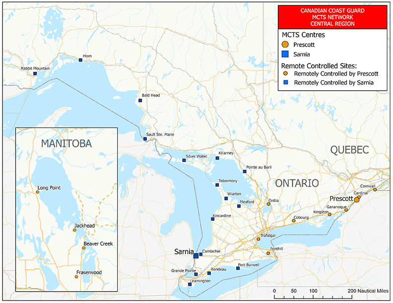
Text Description of Figure 2-1 MCTS Network - Central Region - Great Lakes
The map displays the Canadian Coast Guard’s Marine Communications and Traffic Services (MCTS) communications network covering the Great Lakes portion of the Central Region.
The Prescott MCTS centre remotely controls sites located in Ontario in Cornwall, Cardinal, Gananoque, Kingston, Cobourg, Orillia, Trafalgar and Fonthill and in Lake Winnipeg, Manitoba in Long Point, Jackhead, Beaver Creek and Fraserwood.
The Sarnia MCTS centre remotely controls sites located in Port Burwell, Rondeau, Leamington, Grande Pointe, Camlachie, Kincardine, Meaford, Wiarton, Tobermory, Pointe au Baril, Killarney, Silver Water, Sault Ste. Marie, Bald Head, Horn and Rabbit Mountain.
Figure 2-2 MCTS Network - Central Region – Gulf and St. Lawrence River
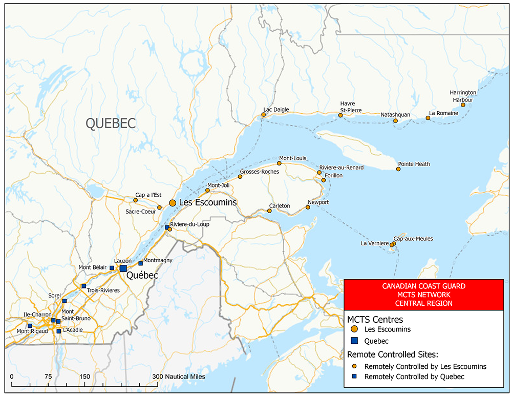
Text Description of Figure 2-2 MCTS Network - Central Region – Gulf and St. Lawrence River
The map displays the Canadian Coast Guard’s Marine Communications and Traffic Services (MCTS) communications network covering the Gulf and St. Lawrence River portion of the Central Region.
The Les Escoumins MCTS centre remotely controls sites located on the Magdalan Islands at Cap-aux-Meules and La Verniere, on Anticosti Island at Pointe Heath and in Quebec at Les Escoumins, Harrington Harbour, La Romaine, Natashquan, Havre St. Pierre, Lac Daigle, Cap à l’Est, Sacré Cœur, Rivière du Loup, Mont-Joli, Grosses-Roches, Mont-Louis, Rivière au Renard, Forillon, Newport and Carleton.
The Québec MCTS centre remotely controls sites located at Rivière du Loup, Montmagny, Lauzon, Mont-Bélair, Trois Rivières, Sorel, Ile Charron, Mont-Rigaud, l’Acadie and Mont Saint-Bruno.
Figure 2-3 MCTS Network - Arctic Region
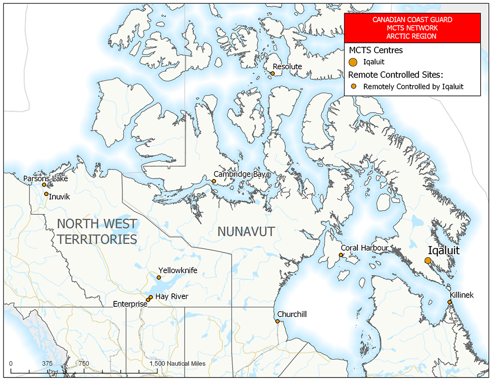
Text Description of Figure 2-3 MCTS Network - Arctic Region
The map displays the Canadian Coast Guard’s Marine Communications and Traffic Services (MCTS) communications network covering the northern Canada portion of the Arctic Region.
The Iqaluit MCTS centre remotely controls sites located in Manitoba in Churchill, in Nunavut in Killinek, Iqaluit, Coral Harbour, Resolute and Cambridge Bay, and in the Northwest Territories in Parsons Lake, Inuvik, Yellowknife, Hay River and Enterprise.
Figure 2-4 MCTS Network – Atlantic Region – Newfoundland and Labrador
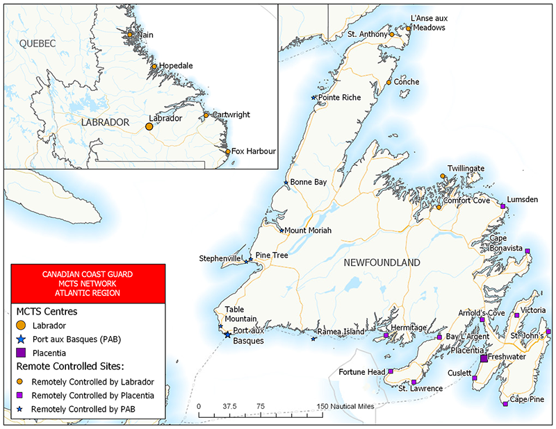
Text Description of Figure 2-4 MCTS Network – Atlantic Region – Newfoundland and Labrador
The map displays the Canadian Coast Guard’s Marine Communications and Traffic Services (MCTS) communications network covering the Newfoundland and Labrador portion of the Atlantic Region.
The Labrador MCTS centre remotely controls sites located in Newfoundland in Goosebay, Comfort Cove, Twillingate, Conche, L’Anse aux Meadows and St. Anthony and in Labrador in Fox Harbour, Cartwright, Hopedale and Nain.
The Placentia MCTS centre remotely controls sites located in Hermitage, Fortune Head, St. Lawrence, Baie L’Argent, Arnold’s Cove, Freshwater, Cuslett, Cape Pine, St. John’s, Victoria, Cape Bonavista and Lumsden.
The Port aux Basques MCTS centre remotely controls sites located in Ramea Island, Table Mountain, Stephenville, Mount Moriah, Bonne Bay and Pointe Riche.
Figure 2-5 MCTS Network – Atlantic Region – Maritimes
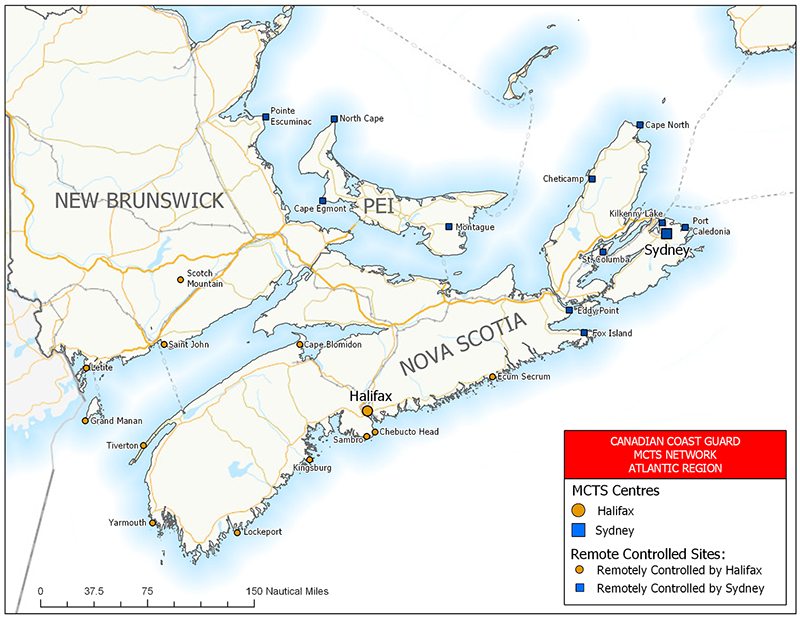
Text Description of Figure 2-5 MCTS Network – Atlantic Region - Maritimes
The map displays the Canadian Coast Guard’s Marine Communications and Traffic Services (MCTS) communications network covering the New Brunswick, Nova Scotia and Prince Edward island portion of the Atlantic Region.
The Halifax MCTS centre remotely controls sites located in New Brunswick in Grand Manan, Letite, Saint John (Red Head) and Scotch Mountain and in Nova Scotia in Cape Blomidon, Tiverton, Yarmouth, Lockeport, Kingsburg, Sambro, Chebucto Head and Ecum Secum.
The Sydney MCTS centre remotely controls sites located in New Brunswick in Point Escuminac, in Prince Edward Island in North Cape, Cape Egmont and Montague and in Nova Scotia in Cape North, Cheticamp, Eddy point, Fox Island, St. Columba, Port Caledonia and Kilkenny Lake.
Figure 2-6 MCTS Network - Western Region
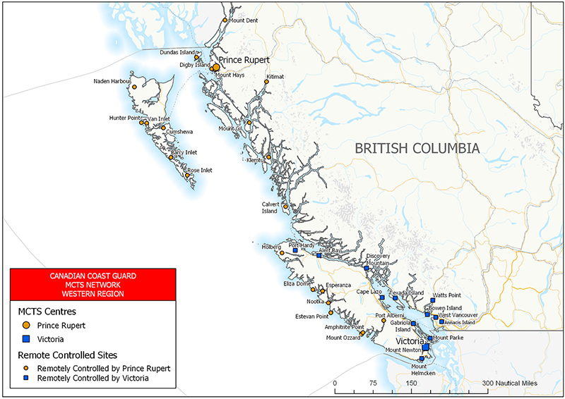
Text description of Figure 2-6 MCTS Network - Western Region
The map displays the Canadian Coast Guard’s Marine Communications and Traffic Services (MCTS) communications network covering Canada’s west coast portion in the Western Region.
The Victoria MCTS centre remotely controls sites located in Port Hardy, Alert Bay, Discovery Mountain, Texada Island, Watts Point, Bowen Island, West Vancouver Island, Annacis Island, Mount Park, Mount Helmcken, Mount Newton, Gabriola Island and Cap Lazo.
The Prince Rupert MCTS centre remotely controls sites located in Port Alberni, Mount Ozzard, Amphritrite Point, Estevan Point, Nootka, Esperanza, Eliza Dorne, Holberg, Calvert Island, Klemtu, Mount Gil, Kitimat, Mount Hays, Digby Island, Dundas Island, Mount Dent, Naden Harbour, Hunter Point, Van Inlet, Cumshewa, Barry Inlet and Rose Inlet.
2.2 Canal and Lock Operations
| Name Coordinates Call Sign |
Class of Service | Channel | Remarks |
|---|---|---|---|
| Canso Lock, N.S. 45°38′04″N 061°24′30″W VAZ3 |
SC | 16 11 |
Operated by Fisheries and Oceans Canada. Canal traffic only. Continuous during navigation season. |
2.3 Canal, Port and Lock Operations
| Name Coordinates Call Sign |
Class of Service | Channel | Remarks |
|---|---|---|---|
| Seaway, Beauharnois Melocheville, Que. 45°18′15″N 073°55′42″W VDX20 |
SC | 16 14 |
Operated by Seaway Management Corporation. Ship traffic control only. |
| Seaway, Iroquois Iroquois, Ont. 44°49′50″N 075°18′46″W VDX21 |
SC | 16 11 |
Operated by Seaway Management Corporation. Ship traffic control only. |
| Seaway, Newcastle Port Hope, Ont. 43°57′38″N 078°16′04″W VDX72 |
SC | 16 11 |
Operated by Seaway Management Corporation. Ship Reports respecting dangers to navigation as required. Ship traffic control only. |
| Seaway Newcastle St. Catharines, Ont. 43°13′01″N 079°12′53″W VDX70 |
SC | 16 11 |
Operated by Seaway Management Corporation. Ship Reports respecting dangers to navigation as required. Ship traffic control only. |
| Toronto, Ont. 43°38′18″N 079°22′49″W XJF46 |
- | 16 12 14 |
All vessels, excepting small craft, entering, leaving or changing berths within the port of Toronto are requested to contact the Toronto Police Marine Unit (Toronto Harbour Communications Centre, Call Sign XJF22) directly on VHF Ch12. At all times, initial calls to the Harbour authority should be made on Ch16. |
| Burlington Canal Bridge, Ont. 43°17′48″N 079°47′42″W XL146 |
SC | 16 12 |
Operated by Department of Public Services and Procurement Canada. Ship traffic control only. |
| Hamilton, Ont. 43°17'00”N 079°50’00”W XJF496 |
- | 16 12 |
All vessels, excepting small craft, entering, leaving or intending to move within the harbour should contact the Hamilton Harbour Master directly on Ch12. Ship traffic control only. |
| Seaway Welland St. Catharines, Ont. 43°49'20"N 079°11'45"W VDX22 |
SC | 16 14 |
Operated by Seaway Management Corporation. Ship traffic control only. |
| Seaway Long Point Port Colborne, Ont. 42°53'15"N 079°14'57"W VDX68 |
SC | 16 11 |
Operated by Seaway Management Corporation. Ship traffic control only. |
| Windsor, Ont. 42°19'00"N 083°04'00"W XJP56 |
- | 16 12 14 |
Operated by the Windsor Port Authority for ship traffic control only. Initial calls to the Harbour Authority should be made on Ch16. |
| Sault Ste. Marie, Ont. Canal Lock 46°30'48"N 084°21'03"W VDX23 |
SC | 16 14 |
Operated by Parks Canada and the City of Sault Ste. Marie. The lock is open from May 15 to October 15 annually. Vessels should make initial calls directly on Ch14. Ship traffic control only. |
| Toronto, Ont. 43°38'28.5" N 079°20'56.5" W XJF46 |
SC | 12 16 |
The Ship Channel Bridge is operated by the Toronto Port Authority. Two hours advance notice is required for a bridge lift at 416 678 6729. |
2.4 Bridge Operations
| Name Coordinates Call Sign |
Class of Service | Channel | Remarks |
|---|---|---|---|
| Johnson Street Bridge Victoria Harbour 48°25'40"N 123°21'52"W VAH20 |
SC | 12 | Operated by the City of Victoria, BC. Ship traffic control only. |
| New Westminster Railway Bridge, B.C. 49°12'32"N 122°53'25"W XLZ35 |
SC | 16 11 12 74 |
Operated by Canadian National Railway. Ship traffic control only. |
| Queensborough Railway Bridge, B.C. 49°11'51"N 122°55'23"W XJJ62 |
SC | 16 74 06 08 |
Operated by Southern Railway of British Columbia Limited. |
| Second Narrows Railway Bridge 49°17'42"N 123°01'27"W CJU52 |
SC | 12 | Operated by Canadian National Railway. Ship traffic control only. |
| Lulu Island Bridge, BC 49° 10′ 58" 122° 59′ 17" W |
SC | 16 |
Operated by Canadian National Railway. Ship traffic control only. |
Note: See current “Sailing Directions” publication for a list of bridges that require radio contact for opening.
2.5 Radio Beacon Stations Continuously in Operations
| Name and Location | Frequency (kHz) |
Range (Nautical Miles) |
Identifier | Remarks | ||
|---|---|---|---|---|---|---|
| Active Pass 48°52'26"N 123°17'23"W |
378 | 50 | • ─ (A) |
• ─ ─ • (P) |
Open year round. Caution: bearing error could result from coastal refraction. (NAV Canada). |
|
| Prince Rupert 54°15'49"N 130°25'20"W |
218 | 100 | • ─ ─ • (P) |
• ─ • (R) |
Open year round (NAV Canada). | |
| Tofino 49°02'54"N 125°42'16"W |
359 | 50 | ─ • ─ ─ (Y) |
• ─ (A) |
─ ─ • • (Z) |
Open year round. Caution: bearing error could result from coastal refraction. (NAV Canada). |
2.6 Radar Beacon (RACONS)
Note:
- A racon’s actual range is dependent on many factors, including, but not limited to, the height of the racon above the water, its type and model, the height of the radar antenna triggering the racon, the radar type, model and settings, as well as the band used (S or X), the prevailing weather conditions, and whether there is a clear line of sight or not.
- As a guideline, and in ideal conditions, the nominal range for a racon installed on a buoy should be between 6 and 8 nautical miles, while the range of a racon installed on a shore structure should be somewhere between 10 and 20 nautical miles.
2.6.1 Atlantic Coast, Gulf and St. Lawrence River (East of Montréal)
| Name and Location | Identifier | Remarks |
|---|---|---|
| Cape Harrigan Light 55°50'34.0"N 060°18'56.8"W |
─ • ─ (K) |
Navigation season only. |
| Channel Head Lightstation 47°33'57"N 059°07'24.6"W |
─ • ─ • (C) |
Open year round. |
| Come by Chance Light and Whistle Buoy « PCC » 47°19'29.4"N 054°07'26.3"W |
• ─ (A) |
Open year round. |
| Domino Point 53°27'42.4”N 055°44'31”W |
─ • ─ ─ (Y) |
Navigation season only. |
| Grappling Island Light 54°27'22.2"N 056°52'52.3"W |
─ ─ • (G) |
Navigation season only. |
| Hens and Chickens 56°30'39.5"N 060°38'37.5"W |
• ─ ─ (W) |
Open year round. |
| Negro Island Light 56°21'05.8"N 060°32'40.8"W |
─ ─ • • (Z) |
Open year round |
| Quaker Hat 54°44'12.5"N 057°20'37.7"W |
─ ─ • ─ (Q) |
Open year round. |
| White Bear Island (Nanuaktok) 55°26'00.7"N 059°30'40.9"W |
─ • (N) |
Navigation season only. |
| Name and Location | Identifier | Remarks |
|---|---|---|
Bear Cove Light and Bell Buoy "H6" |
─ • (N) |
Open year round. |
| Cape Forchu 43°47'38.8"N 066°09'19.3"W |
─ • • • (B) |
Open year round. |
| Cape Sable 43°23'24"N 065°37'16.9"W |
─ • ─ • (C) |
Open year round. |
| Caribou Harbour Light & Bell Buoy "SS1" 45°45'08"N 062°39'44"W |
─ ─ • (G) |
Navigation season only. |
| Chebucto Head Light 44°30'26.6"N 063°31'21.8"W |
─ ─ • • (Z) |
Open year round. |
| Cranberry Islands Light 45°19'29.6"N 060°55'38.2"W |
─ • • • (B) |
Open year round. |
| Lurcher Shoal Bifurcation Light Buoy "NM" 43°48'57"N 066°29'58"W |
─ • ─ (K) |
Open year round. |
| Name and Location | Identifier | Remarks |
|---|---|---|
| Gannet Rock Light 44°30'37.1"N 066°46'52.9"W |
─ ─ • (G) |
Open year round. |
| Miscou Island Light 48°00'33.7"N 064°29'34.7"W |
─ • ─ (K) |
Open year round. |
| Portage Island Channel Range Rear Light 47°07'42.3"N 065°02'31.2"W |
─ ─ • (G) |
Open year round. |
| Saint John Harbour Light and Whistle Buoy "J" 45°12'55.3"N 066°02'36.9"W |
─ • (N) |
Open year round. |
| Shippegan North Channel Light and Whistle Buoy "EE" 47°53'14.2"N 064°45'47.6"W |
─ ─ • (G) |
Open year round. |
| Name and Location | Identifier | Remarks |
|---|---|---|
| Confederation Bridge Pier Shaft 21 46°12'39.9"N 063°45'05.5"W |
─ (T) |
Open year round. |
| Confederation Bridge Pier, Shaft 22 46°12'33.8"N 063°45'13.1"W |
─ • • • (B) |
Open year round. |
| Name and Location | Identifier | Remarks |
|---|---|---|
| Anse aux Basques 48°19'07.5"N 069°24'46.5"W |
─ • ─ (K) |
Open year round. |
| Banc du Cap Brûlé, Downstream Rear Range Light 47°05'22.7"N 070°42'38.9"W |
─ • ─ (K) |
Open year round. |
| Gentilly Front Range Light 46°25'48"N 072°15'46.9"W |
─ • ─ (K) |
Open year round. |
| Île aux Raisins Range Rear Light 46°05'52.7"N 072°57'58.4"W |
─ • ─ (K) |
Open year round. |
| Îles Mermettes / Rivière St-Paul 51°19'20.7"N 057°50'31.3"W |
─ ─ (M) |
Open year round. |
| Île Richelieu 46°38'33.5"N 071°54'35.2"W |
─ ─ (M) |
Open year round. |
| Île Saint-Ours South Light 45°54'20.5"N 073°13'31.5"W |
─ ─ (M) |
Open year round. |
| Lake St. Pierre Upstream (Curve Louiseville) Rear Range Light 46°11'00.4"N 072°55'38.2"W |
─ • (N) |
Open year round. |
| Lavaltrie Rear Range 45°52'43.1"N 073°16'02.6"W |
─ • (N) |
Open year round. |
| Nicolet Sector Light 46°15'27.1"N 072°39'03.5"W |
─ ─ • (G) |
Open year round. |
| Pointe de l’Est, East Cardinal Light Buoy "YY" 47°36'45.2"N 061°19'39.4"W |
─ ─ • (G) |
Navigation season only. |
| Pointe de Manicouagan 49°06'04.4"N 068°11'37.8"W |
─ • • ─ (X) |
Open year round. |
| Pointe du Nord-Est/ Rivière St. Augustin 51°10'37.4"N 058°25'42.7"W (NAD27) |
─ • (N) |
Open year round. |
| Pointe Penouille Rear Range 48°51'11.8"N 064°25'36.3"W |
─ ─ • (G) |
Open year round. |
| Pointes aux Trembles (Neuville) 46°41'47.4"N 071°34'22.5"W |
─ ─ • (G) |
Open year round. |
| Port de Québec – (Pont de Québec, North of Channel) 46°44'47.4"N 071°17'19.1"W |
─ (T) |
Open year round. |
| Port de Québec – (Pont de Québec, South of Channel) 46°44'40.3"N 071°17'14.9"W |
─ • • • (B) |
Open year round. |
| Port de Rimouski Front Range Light 48°28'06.0"N 068°31'06.1"W |
─ • (N) |
Open year round. |
| St. Jean, Île d’Orléans 46°54'56.5"N 070°53'47"W |
─ ─ • (G) |
Open year round. |
| Trois-Rivières-West (Pont Laviolette - North of Channel) 46°18'29.1"N 072°33'45.9"W |
─ (T) |
Open year round. |
| Trois-Rivières-West (Pont Laviolette - South of Channel) 46°18'24.4"N 072°33'37.7"W |
• • • • (H) |
Open year round. |
| Yamachiche Curve Front Range Light / Lac St-Pierre 46°12'18.7"N 072°49'49.1"W |
─ ─ (M) |
Open year round. |
2.6.2 Central Area, including Great Lakes and the St. Lawrence Seaway (West of Montréal)
| Name and Location | Identifier | Remarks |
|---|---|---|
| Kahnawake Front Range 45°24'10.3"N 073°47'45.7"W |
─ ─ • (G) |
Navigation season only. |
| Name and Location | Identifier | Remarks |
|---|---|---|
| Chapman Shoal Light 222, St. Lawrence Seaway (USA) 44°15'27.17"N 076°04’18.45"W |
─ • ─ • (C) |
Operated by USA. |
| Comfort Island Shoal Light 199, St. Lawrence River (USA) 44°19'26.038"N 075°56'19.493"W |
─ ─ (M) |
Operated by USA. |
| Detroit River Light, Detroit River (USA) 42°00'02.9"N 083°08'28.5"W |
─ • • ─ (X) |
Operated by USA. Operational year round. |
| East Outer Channel (Light 1E), Lake Erie (USA) 41°54'48.2"N 083°06'24.1"W |
─ ─ ─ (O) |
Operated by USA. March 15 - January 15 |
| Gereaux Island, Georgian Bay 45°44'40"N 080°39'32.7"W |
─ ─ • (G) |
Navigation season only. |
| Gladman Rock, Georgian Bay 45°20'51.9"N 080°18'52.7"W |
─ ─ • (G) |
Navigation season only. |
| Granite State Shoal Light 214, St. Lawrence Seaway (USA) 44°17'00.69"N 076°00'58.39"W |
─ ─ (M) |
Operated by USA. |
| Lake St. Clair Light, Lake St. Clair (USA) 42°27'55.1"N 082°45'15.4"W |
─ • (N) |
Operated by USA. |
| Light 7, Lake Huron (USA) 43°03'34.838"N 082°25'03.981"W |
─ (T) |
Operated by USA. May 15 - October 15 |
| Light 73 44°55'33.5"N 075°05'43.1"W |
─ ─ (M) |
Operated by USA. Navigation season only. |
| Light Buoy 153 44°30'37.2"N 075°46'07.6"W |
─ ─ (M) |
Operated by USA. Navigation season only. |
| Long Point, Lake Erie 42°32'55.2"N 080°02'58.1"W |
─ ─ (M) |
Operational year round. |
| Mamainse Harbour, Lake Superior 47°02'15.1"N 084°47'11.5"W |
─ ─ (M) |
Navigation season only. |
| Peche Island Range Front Light, Lake St. Clair 42°21’37.556"N 082°54'24.960"W |
─ ─ • (G) |
Operated by USA. |
| Pelee Passage, Lake Erie 41°51'14.9"N 082°34'54.7"W |
─ ─ (M) |
Operational year round. |
| Prescott/Ogdensburg Bridge Piers (North Side), St. Lawrence River 44°44'11.3"N 075°27'37.4"W |
─ (T) |
Navigation season only. |
| Prescott/Ogdensburg Bridge Piers (South Side), St. Lawrence River 44°44'01.7"N 075°27'29.9"W |
• • • • (H) |
Navigation season only. |
| Southeast Shoal, Lake Erie 41°49'34.8"N 082°27'46.1"W |
─ • ─ (K) |
Operational year round. |
2.6.3 Pacific Coast
| Name and Location | Identifier | Remarks |
|---|---|---|
| Alexandra Bank Bifurcation Light Buoy "DAX" 54°14'08.1"N 130°34'06.1"W |
─ • ─ (K) |
Open year round. |
Baird Point |
─ • ─ (K) |
Open year round. |
| Billard Rock Whistle Buoy “M3” Quatsino Sound 50°25'47.2"N 127°57'47.7"W |
─ ─ • (G) |
Open year round. |
| Burrard Inlet Cautionary Light Buoy “QB” 49°19'17.5"N 123°12'06.2"W |
─ • ─ (K) |
Open year round. |
| Butterworth Rocks 54°14'08"N 130°58'30"W (NAD27) |
─ • • ─ (X) |
Open year round. |
| Canoe Pass Light and Bell Buoy “T14” 49°02'17.4"N 123°15'22.7"W |
─ • ─ (K) |
Open year round. |
| Davey Rock Light Buoy “N32” 50°51'36.3"N 127°31'09.7"W |
─ ─ • ─ (Q) |
Open year round. |
| Esperanza Inlet Light and Whistle Buoy “M40” 49°47'07.4"N 127°02'28.5"W |
─ • ─ (K) |
Open year round. |
| Hanmer Rocks, Brown Passage 54°19'26.5"N 130°49'20.3"W |
─ ─ (M) |
Open year round. |
| Jacinto Island 52°56'31"N 129°36'43"W (NAD27) |
─ ─ • ─ (Q) |
Open year round. |
| Juan De Fuca Traffic Lane Separation Light Buoy “J” (USA) 48°29'36.8"N 125°00'00"W |
─ ─ ─ (O) |
Open year round. |
| Lawn Point Sector Light 53°25'29.8"N 131°54'50.3"W (NAD27) |
─ • ─ (K) |
Open year round. |
| Nepean Rock South Cardinal Light and Bell Buoy “EM” 53°12’14.2”N 129°36’26.1”W |
_ . (N) |
Open year round. |
| Pine Island 50°58'32.2"N 127°43'40.7"W |
─ ─ (M) |
Open year round. |
| Race Rocks South Cautionary Light Buoy “VF” 48°14'04.4"N 123°31'58.7"W |
─ • • • (B) |
Open year round. |
| Ridley Island Light and Bell Buoy “D27” 54°11'56.0"N 130°21'26.2"W |
─ ─ • (G) |
Open year round |
| Roberts Bank 49°05'15.7"N 123°18'36.9"W |
─ • (N) |
Open year round. |
| Roberts Bank Cautionary Light Buoy “TA” 49°04'25.4"N 123°22'50.7"W |
─ ─ ─ (O) |
Open year round. |
| Rosario Strait Traffic Separation Lane Lighted Buoy C (USA) 48°40'33.699"N 122°42'48.163"W |
─ • (N) |
Operated by U.S.A. |
| Rosario Strait Traffic Separation Lane Lighted Buoy CA (USA) 48°45'18.384"N 122°46'30.664"W |
─ ─ (M) |
Operated by U.S.A. |
| Rosario Strait Traffic Separation Lane Lighted Buoy RA (USA) 48°19'46.663"N 122°58'38.121"W |
─ • (N) |
Operated by U.S.A. |
| Rosenfeld Rock Light Buoy “U59” 48°48'11.4"N 123°01'38.7"W |
─ • ─ • (C) |
Open year round. |
| Rose Spit 54°09'40"N 131°39'35.2"W (NAD27) |
─ ─ • ─ (Q) |
Open year round. |
| Seal Rocks 53°59'58.8"N 130°47'31.3"W (NAD27) |
─ • ─ ─ (Y) |
Open year round. |
| Seapool Rocks Light and Whistle Buoy “Y49” 48°48'53.3"N 125°12'19.1"W |
─ • ─ (K) |
Open year round. |
| Stenhouse Shoal Light and Whistle Buoy “D59” 54°20'07"N 130°56'03"W |
─ • ─ • (C) |
Open year round. |
| Thrasher Rock 49°09'00"N 123°38'30"W |
─ • •─ (X) |
Open year round. |
| Vancouver Approach Cautionary Light Buoy “QA” 49°16'34.4"N 123°19'18.4"W |
─ ─ • (G) |
Open year round. |
| Victoria Harbour Cautionary Light Buoy “VH” 48°22'31.3"N 123°23'33.7"W |
─ • ─ (K) |
Open year round. |
| Wall Islands 52°51’36.9"N 129°20’50.7"W |
─ • ─ • (C) |
Open year round. |
2.6.4 Arctic Coast and Archipelago
| Name and Location | Identifier | Remarks |
|---|---|---|
| Calton Point 69°30'09"N 139°06'30"W (NAD27) |
─ ─ • (G) |
Navigation season only. |
| Collinson Head 69°34'30"N 138°51'34"W (NAD27) |
─ • (N) |
Navigation season only. |
| Kay Point 69°17'26"N 138°22'42"W (NAD27) |
─ • ─ (K) |
Navigation season only. |
| Shingle Point 69°00'30"N 137°34'12"W |
─ • ─ ─ (Y) |
Navigation season only. |
| Name and Location | Identifier | Remarks |
|---|---|---|
| Churchill 58°47'00.9"N 094°13'59.2"W |
─ ─ • (G) |
Navigation season only. |
| Name and Location | Identifier | Remarks |
|---|---|---|
| Atkinson Point 69°56'46.7"N 131°26'59.3"W |
─ • ─ ─ (Y) |
Navigation season only. |
| Baillie Islands 70°37'38.7"N 128°15'24.8"W |
─ • ─ (K) |
Navigation season only. |
| Cape Dalhousie 70°16'05"N 129°42'36"W (NAD27) |
─ ─ • • (Z) |
Navigation season only. |
| Hardisty Island 61°43'52.6"N 114°35'00.2"W |
─ ─ • (G) |
Navigation season only. |
| Pelly Island 69°37'26.0"N 135°29'15.7"W |
─ • ─ ─ (Y) |
Navigation season only. |
| Pilot Islands 62°13'04"N 114°06'49.3"W |
─ • ─ • (C) |
Navigation season only. |
| Pitt Island 69°09'15"N 136°10'30"W |
─ • ─ (K) |
Navigation season only. |
| Pullen Island 69°46'24.4"N 134°24'04.2"W |
─ ─ • (G) |
Navigation season only. |
| Relief Islet 70°08'45"N 130°49'30"W (NAD27) |
─ ─ • (G) |
Navigation season only. |
| Tuktoyaktuk Island 69°27'21.2"N 132°59'58.8"W |
─ • ─ • (C) |
Navigation season only. |
| Warren Point 69°45'00"N 132°21'30"W |
─ • ─ • (C) |
Navigation season only. |
| Name and Location | Identifier | Remarks |
|---|---|---|
| Beacon Island 58°54'07.9"N 066°20'30.3"W |
─ ─ • (G) |
Navigation season only. |
| Broomfield Island 55°40'24"N 079°14'18"W (NAD27) |
─ • (N) |
Navigation season only. |
| Cache Point 68°39'26.2"N 113°25'11.7"W |
─ ─ • (G) |
Navigation season only. |
| Cape Bexley 69°00'47"N 115°55'24.1"W |
─ • ─ ─ (Y) |
Navigation season only. |
| Coats Island 62°10'20"N 083°08'00"W (NAD27) |
─ • ─ • (C) |
Navigation season only. |
| Delta Island 68°35'15.3"N 100°01'51.9"W |
─ ─ • (G) |
Navigation season only. |
| Kitdliat Island 59°58'34.5"N 069°37'30.6"W |
─ • ─ (K) |
Navigation season only. |
| Mansel Island 62°25'00"N 079°36'30"W (NAD27) |
─ • ─ (K) |
Navigation season only. |
| McClintock Point 69°18'34.2"N 099°53'48.9”W |
─ • ─ • (C) |
Navigation season only. |
| Nipper Island 59°00'26.5"N 068°53'18.0"W |
─ ─ • (G) |
Navigation season only. |
| Nordenskiold Islands 68°21'01.5"N 100°47'22.1"W |
─ • ─ (K) |
Navigation season only. |
| Nottingham Island 63°05'10"N 077°57'00" (NAD27) |
─ • (N) |
Navigation season only. |
| Ristvedt Island 68°30'51.7"N 097°15'13.8"W |
─ • ─ ─ (Y) |
Navigation season only. |
| Sentry Island 61°09'35.6"N 093°52'14.6"W |
─ • ─ • (C) |
Navigation season only. |
| Taylor Point 69°37'11.3"N 095°35'21.7"W |
─ ─ • ─ (Q) |
Navigation season only. |
| Walrus Island 61°57'59.4"N 092°28'41.1"W |
─ • ─ ─ (Y) |
Navigation season only. |
| Wiik Island 68°31'07.1"N 099°33'12.0"W |
─ ─ • • (Z) |
Navigation season only. |
| Name and Location | Identifier | Remarks |
|---|---|---|
| Pointe Qirniraujaq 58°35'00.6"N 068°00'19.0"W |
─ • • ─ (X) |
Navigation season only. |
| Puvirnituq 60°01'15.6"N 077°20'21.3"W |
• ─ ─ • (P) |
Navigation season only. |
- Date modified: