
Radio Aids to Marine Navigation 2024
Part 5: Environment and Climate Change Canada’s Marine and Ice Warning and Forecast Programs
5.1 Background
Environment and Climate Change Canada’s (ECCC) Meteorological Service of Canada (MSC) is the agency responsible for delivering Canada’s weather service. The MSC offers a broad range of products and services that are designed to help mariners make informed decisions on how weather will affect them. The Canadian Coast Guard also plays an important role in disseminating forecasts and warnings, and in collecting and relaying weather information from volunteer observers and ships.
The constant stream of data coming from both automated and manned coastal observation stations, as well as ships and weather buoys, is supplemented by satellite imagery, weather radar and a full set of numerical weather products adapted for marine operations.
5.2 Marine Weather Alerting Program
The MSC is responsible for issuing marine weather alerts for coastal and offshore waters, as well as the St. Lawrence Seaway, and major inland waters such as the Great Lakes. These alerts include warnings of extreme weather events that can pose a threat to life and property at sea, such as gales or storms and freezing spray. Localized warnings and watches are also issued for phenomena such as squalls, high water levels and waterspouts. Advisories are issued as a caution to mariners for weather-related events that may not meet warning criteria but may nonetheless pose significant inconvenience or hazard to navigation.
Major inland waters are defined as having significant marine activity and where time to reach safe harbour is comparable to the marine weather alert lead time. The criteria for issuing marine weather alerts is based on national guidelines, but determined regionally to account for regional climatology and the nature of the regional marine community.
The following tables describe the various types of marine warnings, watches and advisories comprising the Marine Weather Alerting Program:
| Synoptic WarningsFootnote * | Warning Criteria |
|---|---|
| Strong wind warning Footnote 1 | Winds Footnote 2 20 to 33 knots inclusive occurring or expected to occur in any portion of a marine area including any portion defined by a local effect or an “except” statement. |
| Gale warning | Winds Footnote 2 34 to 47 knots inclusive occurring or expected to occur in any portion of a marine area including any portion defined by a local effect or an “except” statement. |
| Storm warning | Winds Footnote 2 48 to 63 knots inclusive occurring or expected to occur in any portion of a marine area including any portion defined by a local effect or an “except” statement. |
| Hurricane force wind warning | Winds Footnote 2 64 knots or above occurring or expected to occur in any portion of a marine area including any portion defined by a local effect or an “except” statement. |
| Freezing spray warning | Ice accretion rate of 0.7 cm/hr or more occurring or expected to occur in any portion of a marine area including any portion defined by a local effect or an “except” statement. |
Range: With the exception of Note (1) above, when a range is used to describe the wind speed, the upper value of the range determines the warning category.
| Localized Warnings/Watches and Advisory Footnote * | Issuing Criteria |
|---|---|
| Squall watch | Advance notice of conditions that are favourable to the development of squalls. |
| Squall warning | Wind gust ≥ 34 knots associated with a line or an organized area of thunderstorms. |
| Tornado watch | Advance notice of conditions that are favourable to the development of tornados. |
| Tornado warning | Evidence of tornado formation (radar, report from a reliable source, etc.) over a marine area, oran existing tornado moving from land to an adjacent marine area. |
| Waterspout watch Footnote 1 | Advance notice of conditions that are favourable to the development of cold-air waterspouts. |
| High water level warning Footnote 2 | Issued to warn mariners and coastal populations of potentially hazardous impacts due to abnormally high water levels or waves along coastal areas. |
| Special marine warning/watch | Used to describe conditions other than those defined above that may have potentially hazardous impacts on navigation. |
| Marine weather advisory Footnote 3 | Issued as necessary to caution mariners about conditions that may not meet established warning criteria but may nonetheless pose significant inconvenience or hazard to navigation. |
Ice warnings: refer to the Canadian Ice Services, Section 5.15.
5.3 Marine and Ice Forecast Program
Marine forecasts are issued for the offshore economic zone including the St. Lawrence Seaway and major inland waters.
For sea ice, ice forecasts are issued for offshore marine areas as well as the Great Lakes. The production schedule is detailed in each regional section of this chapter. The forecast program includes the following bulletins:
| Forecast or bulletin name | Details |
|---|---|
| Technical marine synopsis | Provides the positions and trends of the main weather systems for the forecast period covering Days 1 and 2. |
| Marine forecast (or Regular marine forecast) | Provides information on: synoptic warnings, wind, visibility, precipitation and freezing spray. It may include air temperature as appropriate. Valid for Days 1 and 2. |
| Recreational boating marine forecast | Tailored to the needs of recreational boaters, it is available on a seasonal basis and only in specific regions. |
| Wave height forecast | Provides information on significant wave heights for Days 1 and 2 (not available for northern and Arctic lakes or inland waterways). |
| Extended marine forecast | Meant for longer-range planning purposes, it provides an extended marine wind outlook for Days 3, 4, and 5. |
| Iceberg bulletin | Provides information on distribution of icebergs valid for the time of issue of the bulletin. |
| Ice forecasts | Provides information on hazardous ice conditions for Days 1 and 2. |
| NAVTEX Footnote 1 | International Maritime Organization (IMO)-compliant NAVigational TelEX bulletin issued with each regular marine forecast or ice forecasts in a standardized abbreviated format - see section 5.7.1 for Abbreviations. |
| MAFOR Footnote 1 | This is a specialized coded marine forecast produced for Québec and Ontario regions. |
5.3.1 Monitoring the Forecast
Forecasts are monitored, and amended as necessary, to reflect unexpected or changing weather conditions according to criteria based on the following principles:
- when safety or security is at risk;
- when inconvenience to the marine community will be extensive; or
- when the product could adversely affect the credibility of the marine forecast program.
5.3.2 Marine and Ice Forecast Areas
Marine forecasts and ice forecasts are issued for marine and ice areas as outlined in the regional maps. The sizes and boundaries of these areas are determined regionally based on the following considerations:
- marine traffic density;
- the ability to forecast to the proposed resolution;
- the degree to which, climatologically, marine weather varies; and
- the ability to distribute the information effectively to the marine community.
5.3.3 Current Conditions
Current weather data is available to Canadians for their local area. The frequency and quality of the data will be consistent with the standards established by the World Meteorological Organization (WMO). The data may include, as appropriate:
- wind speed and direction;
- atmospheric pressure;
- sky conditions;
- precipitation type;
- restrictions to visibility;
- wave height; and
- current temperature.
General information on current sea-ice will be provided to the marine community once a week to provide an adequate planning tool for those considering entering ice-encumbered waters.
5.3.4 Emergency Response
Meteorological support is provided during emergencies and includes the provision of meteorological information and forecasts. In the case of a pollution event, Environment and Climate Change Canada adheres to the “polluter pay” policy for the provision of all services. Where agreements are in place, Environment and Climate Change Canada will make its distribution systems available to transmit vital information during emergency situations.
5.3.5 Delivery of Marine Warning and Forecast Services
Delivery of marine warning and forecast services to mariners navigating waters within Environment and Climate Change Canada’s forecast areas of responsibility is primarily by mass communication in order to reach the greatest number of mariners through the standard communications technologies available to mariners. The following principles apply, regardless of the specific available technologies:
- Marine forecasts and warnings comprising the meteorological Maritime Safety Information (met MSI) issued by Environment and Climate Change Canada will be made available to the marine community via the CCG MCTS according to established procedures within the framework of the Global Maritime Distress and Safety System (see RAMN Part 4 Section 4.2.1 General Procedures – Systems – GMDSS).
- All forecast and warning information will be found at the Government of Canada web page. Mariners should note, however, that the internet is not part of the Maritime Safety Information system and should never be relied upon as the only means to obtain the latest marine forecasts and warning information. Access to the internet may be interrupted or updated information delayed without prior notice.
- Marine and Environmental Advisories, Watches and Warnings are distributed through various mechanisms including partnerships with national and regional media distributors and local emergency measures organizations.
- In addition to the aforementioned mediums, basic services to mariners and Canadians in general shall also be delivered by mass distribution in partnership with media, relying on current and developing technologies in radio, television, newspaper and the Internet. These distribution mechanisms represent the primary methods by which most Canadians receive their weather information, now and in the future.
5.4 Voluntary Observing Ship (VOS) Program
The VOS program has been discontinued within Canada. Environment and Climate Change Canada currently supports the Automated Voluntary Observing Ship program (AVOS) program and will support visiting VOS ships from other jurisdictions on a “best efforts” basis. Contact your regional PMO for further information.
5.5 Buoys Program
In order to complement the observational network, Environment and Climate Change Canada operates a network of buoys across the country. This data becomes part of the collection of weather reports sent to the distribution network and is used to improve marine forecasting. The location, WMO identifiers and names of the Environment and Climate Change Canada buoys are given in the regional annexes.
Mariners are requested to use caution when approaching buoys as mooring chains are normally not detectable from a ship and can be damaged or even severed if there is contact. Such a mishap could possibly result in the buoy going adrift thus requiring a costly effort to recover the platform. Please keep the regional PMO informed of any incidents involving buoys.
Buoy locations: Buoy positions are described in each specific regional annex.
5.6 Port Meteorological Officers (PMOs)
In addition to a variety of other duties, PMOs also act as a liaison between Environment and Climate Change Canada and ships involved in the VOS and AVOS programs. This is to encourage vessels to report weather and ice conditions, to instruct observers about procedures and the use of code; to supply observing forms, handbooks (free of charge); to calibrate equipment; and, in some cases, to install, on loan, meteorological or oceanographic instrumentation. The PMO is also responsible for recruiting new vessels to participate in the AVOS program.
If a PMO visits your ship, feel free to ask questions about observing and coding, and reporting weather and ice conditions. Inform the PMO of any concerns you may have with forecasts, warnings, or facsimile products, especially if you have specific problems. The PMO will contact the appropriate party for investigation. Keep the PMO informed of your contact information.
5.6.1 Port Meteorological Officers (PMOs)
Great Lakes
Eugene Letourneau, PMO
Environment and Climate Change Canada, MSC
867 Lakeshore Road
Burlington ON L7S 1A1
Telephone: 905-336-4906
Cellular: 647-291-7135
Email: eugene.letourneau@ec.gc.ca
Atlantic - Maritimes
Derek Cain, PMO
Environment and Climate Change Canada, MSC
275 Rocky Lake Drive
Bedford, NS B4A 2T3
Telephone: 902-426-6616
Cellular: 902-222-6325
Facsimile: 902-426-6404
Email: derek.cain@ec.gc.ca
Atlantic - Newfoundland
Andre Dwyer, PMO
Environment and Climate Change Canada, MSC
6 Bruce Street
Mount Pearl NL A1N 4T3
Telephone: 709-772-4798
Cellular: 709-689-5787
Facsimile: 709-772-5097
Email: andre.dwyer@ec.gc.ca
St. Lawrence - Québec
Patrice Lévesque, PMO
Environment and Climate Change Canada, MSC
10th Floor
305 boul. René-Lévesque Ouest
Montréal, QC H2Z 1A6
Cellular: 514-213-4544
Email: patrice.levesque@ec.gc.ca
Pacific
Dragan Radovic, PMO
Environment and Climate Change Canada, MSC
140 13160 Vanier Place
Richmond BC V6V 2J2
Cellular: 604-340-2153
Telephone: 604-713-9523
Facsimile: 604-664-4094
Email: dragan.radovic@ec.gc.ca
Great Slave Lake / Lake Athabasca / Western Arctic
John Burrows, PMO
Daniel Seburn, PMO
Environment and Climate Change Canada, MSC
M.J. Greenwood Centre
9345 - 49 Street
Edmonton AB T6B 2L8
Telephone: 780-495-5476 or 780-495-6442
Facsimile: 780-495-7739
Email: john.burrows@ec.gc.ca
Email: daniel.seburn@ec.gc.ca
Manitoba Lakes
Rich DeVall, PMO
Monitoring and Systems
Environment and Climate Change Canada, MSC
Suite 150, 123 Main Street
Winnipeg MB R3C 4W2
Telephone: 204-983-2068
Cellular: 204-293-3607
Facsimile: 204-984-2072
Email: rich.devall@ec.gc.ca
5.7 NAVTEX
MSC will provide Canadian Coast Guard with marine forecast information in NAVTEX format for coastal and offshore areas of responsibility based on IMO standards. Marine forecast information provided will include:
- warnings (winds and ice accretion);
- synopsis (major features); and
- forecasts (wind, visibility, ice accretion, wave height).
Each bulletin will contain a WMO telecommunication header, a valid period, notes on parameters used within the bulletin, a synopsis section, a weather forecast section and a wave forecast section. Below is a sample of a partial NAVTEX produced for CCG MCTS Sydney. Note that NAVTEX will make use of abbreviations: this is necessary in order to comply with the physical limitations of the NAVTEX system. In the example, text in superscript indicates how abbreviations are used. Section 5.7.1 provides a detailed list used by NAVTEX.
| - | NAVTEX service sample (518 kHz) |
|---|---|
| Header | FQCN34 CWHX 171400 |
| Title(part one) | NAVTEX/1 FOR SYDNEY VCO AT 10:00 AM AST FRI Friday 17 NOV November 2006. |
| Weather forecast | |
| Parameters | VLD valid period 17/14Z-19/03Z, WND(KT) wind in knots, VIS(NM) visibility in nautical miles ABV above 1 NM UNL IND unless indicated, FOG IMPLIES VIS 1 NM OR LESS. |
| Synopsis | SYNOPSIS: 17/14Z STRM storm 980 MB OVR SRN NFLD over southern Newfoundland 18/14Z STRM storm 985 MB OVR NRN NFLD. over northern Newfoundland 17/14Z RIDG OVR WRN QUE. ridge over western Québec 18/14Z RIDG OVR WRN GU ST LAW. ridge over western Gulf of St Lawrence |
Area name Warning Wind forecast Visibility forecast End of weather |
EASTERN SHORE, FOURCHU: WNG warning: NIL. WND: SWsouthwest10-15. 17/18Z SEsoutheast15-20. 18/06Z V15. 18/12Z SWsouthwest15-20. 18/18Z SW20-25. 19/00Z SW15-20. VIS: 17/13Z-19/03Z PTH-FG .fog banks {... other marine areas } END/ |
| Wave height forecast | |
Parameters Area name |
WAVES(M) metres VLD 17/09Z-18/10Z. EASTERN SHORE, SABLE, EAST SCOTIAN SLOPE–N – northern half, FOURCHU, BANQUEREAU: |
| Height in meters | 1-2. |
End of waves and part one |
{.... Other marine areas} END/ |
Mariners navigating northern and Arctic waters are advised that marine forecast bulletins issued for MSC’s METAREAs marine forecast service uses similar abbreviated text formatting as is used in the NAVTEX marine weather bulletins issued by the MSC. Further information regarding the METAREAs forecast program is provided in RAMN Part 5, Section 5.9 Northern Canada.
5.7.1 Abbreviations Used by MSC within NAVTEX and METAREAs Bulletins
Note: Only terms that are abbreviated for use in the NAVTEX bulletins are listed in the following NAVTEX abbreviation tables.
| Abbreviation | Term |
|---|---|
| APR | April |
| AUG | August |
| DEC | December |
| FEB | February |
| FRI | Friday |
| JAN | January |
| JUL | July |
| JUN | June |
| MAR | March |
| MON | Monday |
| NOV | November |
| OCT | October |
| SAT | Saturday |
| SEP | September |
| SUN | Sunday |
| TDY | Today |
| THU | Thursday |
| TNGHT | Tonight |
| TUE | Tuesday |
| WED | Wednesday |
| Abbreviation | Term |
|---|---|
| -E | - eastern half |
| -N | - northern half |
| -NE | - northeastern half |
| -NW | - northwestern half |
| -S | - southern half |
| -SE | - southeastern half |
| -SW | - southwestern half |
| -W | - western half |
| LCLY | locally |
| XCPT | except |
| Abbreviation | Term |
|---|---|
| IMPL | implies |
| IND | indicated |
| KT | knots |
| M | meters |
| MB | millibar |
| NM | nautical mile |
| UNL | unless |
| VLD | valid |
| Abbreviation | Term |
|---|---|
| E | east |
| G | with gusts to |
| LGT | light |
| N | north |
| NE | northeast |
| NW | northwest |
| S | south |
| SE | southeast |
| SW | southwest |
| VRB | variable |
| W | west |
| WND | wind |
| WNG | warning |
| Abbreviation | Term |
|---|---|
| MOD | moderate |
| OCNL | at times |
| OUT-EDGE | outside the ice edge |
| OVR-OW | over open water |
| RSK | risk |
| SEV | severe |
| Abbreviation | Term |
|---|---|
| ICE | ice covered |
| Abbreviation | Term |
|---|---|
| BS | blowing snow |
| BZ | blizzard |
| DZ | drizzle |
| FG | fog |
| FRZ-DZ | freezing drizzle |
| FRZ-RA | freezing rain |
| HL | hail |
| HVY-RA | heavy rain |
| HVY-SN | heavy snow |
| IFG | ice fog |
| IP | ice pellets |
| LGT-SN | flurries |
| LGT-SN | light snow |
| MIX-RASN | rain and snow mixed |
| MST | mist |
| PTH-FG | fog banks |
| PTH-MIST | mist patches |
| RA | rain |
| SCT | scattered |
| SHWRS | showers |
| SN | snow |
| STRG-TS | heavy thunderstorm |
| TSTM | thunderstorm |
| WTSPT | waterspout |
| Abbreviation | Term |
|---|---|
| 0-1 | one mile or less |
| ABV 1 | above one mile |
| GOOD | good Footnote * |
| HVY | heavy |
| IN-PRECIP | in precipitation |
| MOD | moderate Footnote * |
| NR 0 | near zero |
| NR 1 | as low as 1 mile |
| OCNL | at times |
| OCNL | occasional |
| POOR | poor Footnote * |
| VERY POOR | very poor Footnote * |
| VIS | visibility |
| Abbreviation | Term |
|---|---|
| APCHG | approaching |
| BLDN | building |
| DISS | dissipating |
| DPN | deepening |
| DPRTG | departing |
| INTSF | intensifying |
| MERG | merging |
| Q-STNR | quasi-stationary |
| SPLIT | splitting |
| WKN | weakening |
| Abbreviation | Term |
|---|---|
| C-FRONT | cold front |
| DISTURB | disturbance |
| FRONT | frontal system |
| HURR | hurricane |
| POST-TROP-STRM | post tropical storm |
| STRM | storm |
| TROP-DEP | tropical depression |
| TROP-STRM | tropical storm |
| W-FRONT | warm front |
| Abbreviation | Term |
|---|---|
| CAP | cape |
| CSTL | coastal |
| EXTDG | extending |
| FM | from |
| FM | located from |
| IS | island |
| LAT | latitude |
| LK | lake |
| LONG | longitude |
| NR | located near |
| NR | near |
| OFF | located off |
| ON LINE | located on a line |
| OVR | over |
| PEN | peninsula |
| RIV | river |
| STR | strait |
| Abbreviation | Term |
|---|---|
| E | east |
| ERN | eastern |
| E-W | east – west |
| FM | from |
| N | north |
| NE | northeast |
| NERN | northeastern |
| NE-SW | northeast-southwest |
| NRN | northern |
| N-S | north - south |
| NW | northwest |
| NWRN | northwestern |
| NW-SE | northwest-southeast |
| S | south |
| SE | southeast |
| SERN | southeastern |
| SRN | southern |
| SW | southwest |
| SWRN | southwestern |
| W | west |
| WRN | western |
| Abbreviation | Term |
|---|---|
| ALTA | Alberta |
| BC | British Columbia |
| GRT LKS | Great Lakes |
| GU ST LAW | Gulf of St Lawrence |
| LAB | Labrador |
| MAN | Manitoba |
| NB | New Brunswick |
| NFLD | Newfoundland |
| NL | Newfoundland and Labrador |
| NS | Nova Scotia |
| NU | Nunavut |
| NWT | Northwest Territories |
| ONT | Ontario |
| PAC | pacific |
| PEI | Prince Edward Island |
| QUE | Québec |
| SASK | Saskatchewan |
| YT | Yukon Territory |
5.7.2 Ice Elements
| Abbreviation | Term |
|---|---|
| 1 | 1 tenth |
| 2 | 2 tenths |
| 3 | 3 tenths |
| 4 | 4 tenths |
| 5 | 5 tenths |
| 6 | 6 tenths |
| 7 | 7 tenths |
| 8 | 8 tenths |
| 9 | 9 tenths |
| 9+ | 9 plus tenths |
| 9-10 | 9 to 10 tenths (lake ice) |
| 10 | 10 tenths |
| BW | bergy water |
| CONS | consolidated |
| IF | ice free |
| OW | open water |
| TR- | trace of |
| Abbreviation | Term |
|---|---|
| FI | fast ice |
| FYI | first-year ice |
| GI | grey ice |
| GWI | grey-white ice |
| MEDI | medium lake ice |
| MYI | multi-year ice |
| NI | new ice |
| NI | new lake ice |
| OI | old ice |
| SYI | second year ice |
| THI | thin lake ice |
| TKI | thick lake ice |
| VTKI | very thick lake ice |
| Abbreviation | Term |
|---|---|
| LGT | light |
| MOD | moderate |
| PRESS | pressure |
| STRG | strong |
| Abbreviation | Term |
|---|---|
| ALNG CST | along the coast |
| CDNS | conditions |
| EST | estimated |
| INCL | including |
| POSS | possible |
| XCPT | except |
| Abbreviation | Term |
|---|---|
| EWD | eastward |
| NEWD | northeastward |
| NWD | northward |
| NWWD | northwestward |
| SEWD | southeastward |
| SWD | southward |
| SWWD | southwestward |
| WWD | westward |
5.8 Mafor Decode Table
MAFOR
YYG1G1/
0AAAam
1GDFmWm
| am | Portion of the maritime area |
|---|---|
| Code 0 | Whole of the area AAA |
| Code 1 | Northeast quadrant of the area AAA |
| Code 2 | Eastern half of the area AAA |
| Code 3 | Southeast quadrant of the area AAA |
| Code 4 | Southern half of the area AAA |
| Code 5 | Southwest quadrant of the area AAA |
| Code 6 | Western half of the area AAA |
| Code 7 | Northwest quadrant of the area AAA |
| Code 8 | Northern half of the area AAA |
| Code 9 | Rest of the area AAA |
1GDFmWm
G: Forecast period
D: Direction from which the wind is blowing
Fm: Wind speed
Wm: Forecast weather
| G | Forecast period | D | Wind | Fm | Wind | Wm | Forecast weather |
|---|---|---|---|---|---|---|---|
| Code | Descriptive | Code | Direction | Code | Knots | Code | - |
| 0 | Beginning of period | 0 | Calm | 0 | 0 - 3 | 0 | Visibility greater than 3 nm. |
| 1 | Valid for 3 hrs | 1 | Northeast | 1 | 4 | 1 | Risk of accumulation of ice on superstructures. |
| 2 | Valid for 6 hrs | 2 | East | 2 | 5 | 2 | Strong risk of accumulation of ice on superstructure. |
| 3 | Valid for 9 hrs | 3 | Southeast | 3 | 6 | 3 | Visibility ≥ 1 nm and ≤ 3 nm. |
| 4 | Valid for 12 hrs | 4 | South | 4 | 7 | 4 | Visibility < 1 nm, including fog. |
| 5 | Valid for 18 hrs | 5 | Southwest | 5 | 8 | 5 | Drizzle |
| 6 | Valid for 24 hrs | 6 | West | 6 | 9 | 6 | Rain |
| 7 | Valid for 48 hrs | 7 | Northwest | 7 | 10 | 7 | Snow, or rain and snow |
| 8 | Valid for 72 hrs | 8 | North | 8 | 11 | 8 | Squally weather with or without showers. |
| 9 | Occasionally | 9 | Variable | 9 | 12 | 9 | Thunderstorms |
Suggestions/Comments Form
Text Description: Environment Canada Suggestions Form
A form to provide comments regarding the Environment Canada Marine and Ice Servcies. The form requires the inclusion of the following information:
- Officer Name
- Ship Identification
- Position Latitude
- Position Longitude
- Date
The comments can be forwarded to the following coordinates:
Weather Service Programs Division
National Service Operations Division
Environment Canada
P.O.Box 370
Gander, NL
A1V 1W7
Facsimile: (709) 256-6627
5.9 Northern Canada
Includes: Western and Eastern Arctic, Hudson Bay and Major Inland Lakes of Manitoba, Northern Saskatchewan and Northwest Territories.
5.9.1 Marine Weather Forecast Program
The Prairie and Arctic Storm Prediction Centre (PASPC), which is jointly located in Edmonton and Winnipeg provides marine weather forecasts in support of Arctic marine activity during the open water season from summer into parts of the fall. Wave height forecasts are provided for salt water areas. The PASPC-Edmonton forecast area encompasses Lake Athabasca, Great Slave Lake, the Mackenzie River, as well as the waterways of the Western and High Arctic, and Baffin Bay.
The PASPC-Winnipeg provides marine forecasts for Hudson Bay, Hudson Strait, Foxe Basin, Ungava Bay, and Davis Strait. Marine forecasts are also provided for Lake Winnipeg (north and south basins), Lake Manitoba and Lake Winnipegosis during the open water season in support of pleasure and commercial activities.
The forecast program for the Manitoba Lakes continues through the winter months as a public rather than a marine forecast in aid of commercial ice fishing. Minimum and maximum temperatures along with wind chill are included in the forecast.
| Forecast Name | Issue Time | Time Zone | Marine Region |
|---|---|---|---|
| Technical marine synopsis | 06:30, 18:30 | MDT/MST | Western Arctic |
| 06:30, 18:30 | MDT/MST | Central Arctic | |
| 04:45, 16:45 | EDT/EST | Hudson Bay and Eastern Arctic | |
| Marine forecast | 03:00, 11:30, 16:30 | CDT/CST | Manitoba |
| 05:00, 17:00 | MDT/MST | Inland waters (Lake Athabasca, Great Slave Lake, the Mackenzie River) | |
| 07:00, 19:00 | MDT/MST | Western Arctic Waterway | |
| 05:30, 17:30 | EDT/EST | Arctic | |
| 05:00, 17:00 | CDT/CST | Hudson Bay | |
| 05:30, 17:30 | EDT/EST | Southern Nunavut | |
| 05:00, 17:00 | EDT/EST | Eastern Nunavut | |
| Extended forecast | 05:00, 17:00 | MDT/MST | Inland waters |
| 07:00, 19:00 | MDT/MST | Western Arctic Waterway | |
| 05:30, 17:30 | EDT/EST | Arctic | |
| 05:00, 17:00 | CDT/CST | Hudson Bay | |
| 05:30, 17:30 | EDT/EST | Southern Nunavut | |
| 05:00, 17:00 | EDT/EST | Eastern Nunavut | |
| Wave height forecast | 07:00, 19:00 | MDT/MST | Western Arctic Waterway |
| 05:30, 17:30 | EDT/EST | Arctic | |
| 05:00, 17:00 | CDT/CST | Hudson Bay | |
| 05:30, 17:30 | EDT/EST | Southern Nunavut | |
| 05:00, 17:00 | EDT/EST | Eastern Nunavut | |
| Marine weather statement | As needed | MDT/MST EDT/EST |
Where needed |
| MCTS Centre | NAVTEX Transmitter | Header | Issue Time |
|---|---|---|---|
| Iqaluit/ VFF | Iqaluit | FQCN36 CWNT FICN36 CWIS |
05:30, 17:30 EDT/EST 7:00, 19:00 UTC |
Note:
Refer to Part 2 for the MCTS broadcast schedule
Marine Weather Warnings (refer to Table 5-1 - Synoptic Warnings)
Note the following particulars:
| - | Warning Types | Comments |
|---|---|---|
| 1 | Strong wind warning | Applies to Manitoba Lakes, Lake Athabasca, Great Slave Lake and Mackenzie River |
5.9.2 Weather and Ice Messages
Ship weather and ice reports in the international meteorological code, taken at the standard synoptic hours of 00:00, 06:00, 12:00 and 18:00 UTC are solicited from ships of all nationalities which have been recruited by their national weather service, or other weather services. These reports should be transmitted directly to the circuit using Inmarsat. Alternatively, the observation should be passed to the nearest CCG MCTS Centre, irrespective of the ship’s position. Reports made close to, or even within sight of land, are as important as reports made offshore, due to the greater variability of weather conditions in proximity to a coastline. Such reports contribute to the overall knowledge of Arctic weather from both a real-time operational perspective and from a climate perspective.
The PASPC welcomes weather, sea, and ice observations from the lakes. Real-time observations, and those up to a few hours after the event, are most valuable. Relay observations to 1 800 66STORM (1-800-667-8676).
5.9.3 Weatheradio Canada
Weatheradio is a public service designed to make weather information available over VHF or FM radio continuously. Weatheradio is dedicated to transmitting up to the minute weather reports and forecasts directly to all users including the marine community.
Environment and Climate Change Canada Weatheradio operates several stations serving Northern region. These are:
| Station | Call Sign | Frequency (MHz) |
Effective Radiated Power (Watts) | Location |
|---|---|---|---|---|
| Arviat | CKO583 | 162.400 | 27 | Arviat |
| Behchoko | CHR950 | 162.475 | 302 | Behchoko |
| Cap Dorset (Kingait) | XJS717 | 162.550 | 25 | Cap Dorset (Kingait) |
| Dauphin | VBA814 | 162.550 | 123 | Moon Lake |
| Fort McPherson | CHR956 | 162.450 | 245 | Fort McPherson |
| Fort Providence | CHR951 | 162.425 | 303 | Fort Providence |
| Fort Simpson | CHR952 | 162.400 | 76 | Fort Simpson |
| Fort Smith | CFM468 | 162.425 | 309 | Fort Smith |
| Hay River | CIE211 | 162.550 | 245 | Hay River |
| Inner Whaleback Rocks | XKI403 | 161.650 | 8 | Inner Whaleback Rocks |
| Inuvik | VBU996 | 162.400 | 54 | Hidden Lake |
| Iqaluit | VEV284 | 162.550 | 30 | Iqaluit |
| Iqaluit (FM) | CIQA | 93.3 | 42 | Iqaluit Airport |
| Long Point Footnote * | VCI386 | 162.550 | 72 | Long Point |
| Nahanni Butte | CHR957 | 162.525 | 224 | Nahanni Butte |
| Norman Wells | CHR953 | 162.400 | 269 | Norman Wells |
| Pine Point | XJS786 | 162.475 | 389 | Pine Point |
| Rankin Inlet (Kangiqliniq) | XJS716 | 162.400 | 40 | Rankin Inlet (Kangiqliniq) |
| Riverton Footnote * | XLF471 | 162.400 | 195 | Riverton |
| Tuktoyaktuk | CHR955 | 162.475 | 269 | Tuktoyaktuk |
| Winnipeg Footnote * | XLM538 | 162.550 | 126 | Trizic Building |
| Yellowknife | VBC200 | 162.400 | 148 | Yellowknife Seismic Station |
| WMO# | Location/Information | LAT (deg) |
LONG (deg) |
|---|---|---|---|
| 45140 | Lake Winnipeg South Basin (moored buoy) | 50.790 N | 096.733 W |
| 45141 | Great Slave (moored buoy 25 nm northeast of Hay River) | 61.181 N | 115.314 W |
| 45144 | Lake Winnipeg North Basin (moored buoy) | 53.380 N | 098.480 W |
| 45145 | Lake Winnipeg between North and South Basins | 51.870 N | 096.970 W |
| 45150 | Great Slave (moored buoy - immediate west of InnerWhaleback Rocks) | 61.981 N | 113.136 W |
The Great Slave Lake buoys are deployed in early July and retrieved in late September or early October. They provide hourly wind, air temperature, surface water temperature, and wave data.
The Lake Winnipeg South Basin buoys are deployed annually in May or June, and retrieved in October. They provide hourly wind, air temperature, surface water temperature, and wave data.
Figure 5-1 - Marine Forecast Areas: Northern Canada
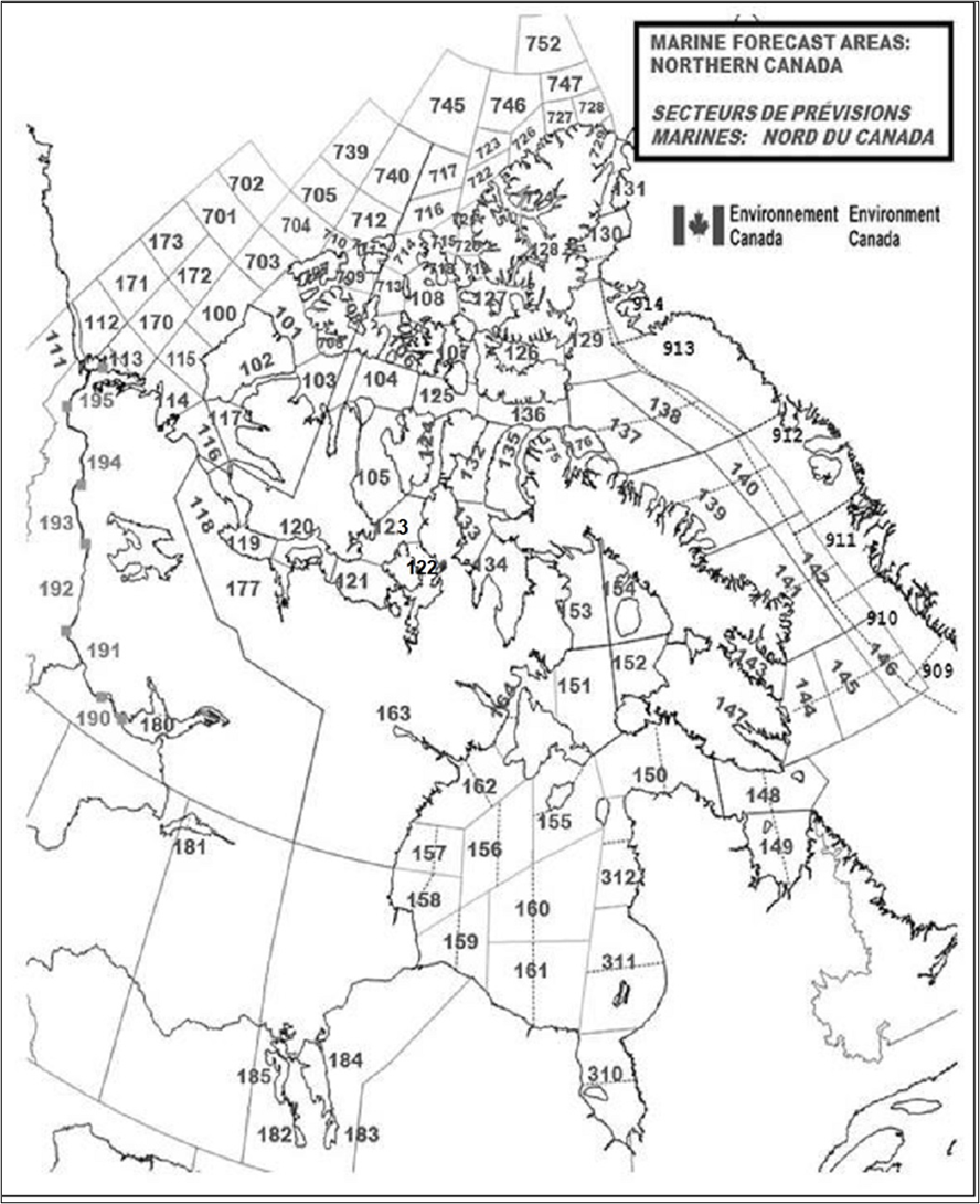
Text description of Figure 5-1 Marine forecast areas for Northern Canada
The above map depicts the northern and Arctic marine forecast zones within Canada’s Exclusive Economic Zone, including the northern inland lakes and waterways, as well as the Danish marine forecast areas along the western Greenlandic coast. Each individual forecast zone has been assigned a unique number. The number corresponding to each forecast zone, along with the forecast zone name, is listed in the Marine Forecast Areas tables below for the Eastern and Western Arctic Waters and Hudson Bay, Inland Waters, and the Danish Marine Forecasts for Baffin Bay. These marine forecast zones may also be accessed on Environment Canada’s Weather web page at the following links:
5.9.4 Marine Forecast Areas
| Number | Area Name | Forecast Availability Period Footnote * |
|---|---|---|
| 100 | Prince Alfred | Shipping season |
| 101 | McClure | Shipping season |
| 102 | Prince of Wales | Shipping season |
| 103 | Melville | Shipping season |
| 104 | Rae | Shipping season |
| 105 | McClintock | Shipping season |
| 106 | Byam | Shipping season |
| 107 | Queens | Shipping season |
| 108 | Maclean | Shipping season |
| 109 | (unused) | - |
| 110 | (unused) | - |
| 111 | Yukon Coast | Shipping season |
| 112 | Mackenzie | Shipping season |
| 113 | Tuktoyaktuk | Shipping season |
| 114 | Baillie | Shipping season |
| 115 | Banks | Shipping season |
| 116 | Amundsen | Shipping season |
| 117 | Ulukhaktok | Shipping season |
| 118 | Dolphin | Shipping season |
| 119 | Coronation | Shipping season |
| 120 | Dease | Shipping season |
| 121 | Maud | Shipping season |
| 122 | St-Roch | Shipping season |
| 123 | Larsen | Shipping season |
| 124 | Peel | Shipping season |
| 125 | Barrow | Shipping season |
| 126 | Jones | Shipping season |
| 127 | Norwegian | Shipping season |
| 128 | Eureka | Shipping season |
| 129 | Clarence | Shipping season |
| 130 | Kane | Shipping season |
| 131 | Robeson | Shipping season |
| 132 | Regent | Shipping season |
| 133 | Boothia | Shipping season |
| 134 | Committee | Shipping season |
| 135 | Admiralty | Shipping season |
| 136 | Lancaster | Shipping season |
| 137 | West Baffin | Shipping season |
| 138 | East Baffin | Shipping season |
| 139 | West Clyde | Shipping season |
| 140 | East Clyde | Shipping season |
| 141 | West Davis | Shipping season |
| 142 | East Davis | Shipping season |
| 143 | Cumberland | Shipping season |
| 144 | West Brevoort | Shipping season |
| 145 | Central Brevoort | Shipping season |
| 146 | East Brevoort | Shipping season |
| 147 | Frobisher Bay | Shipping season |
| 148 | Resolution | Shipping season |
| 149 | Ungava | Shipping season |
| 150 | Nottingham | Shipping season |
| 151 | West Foxe | Shipping season |
| 152 | East Foxe | Shipping season |
| 153 | Igloolik | Shipping season |
| 154 | Prince Charles | Shipping season |
| 155 | Coats | Shipping season |
| 156 | Central | Shipping season |
| 157 | Arviat | Shipping season |
| 158 | Churchill | Shipping season |
| 159 | York | Shipping season |
| 160 | South-Central Hudson | Shipping season |
| 161 | South Hudson | Shipping season |
| 162 | Rankin | Shipping season |
| 163 | Baker | Shipping season |
| 164 | Roes Welcome | Shipping season |
| 170 | North Tuktoyaktuk | Shipping season |
| 171 | North Mackenzie | Shipping season |
| 172 | West Prince Alfred | Shipping season |
| 173 | Northwest Beaufort | Shipping season |
| 175 | Navy Board | Shipping season |
| 176 | Pond | Shipping season |
| 177 | Bathurst | Shipping season |
| 310 | James Bay | Shipping season |
| 311 | Belcher | Shipping season |
| 312 | Puvirnituq | Shipping season |
| 701 | CT4 | Shipping season |
| 702 | CU4 | Shipping season |
| 703 | South Prince-Patrick | Shipping season |
| 704 | Prince Patrick | Shipping season |
| 705 | North Prince Patrick | Shipping season |
| 706 | Liddon | Shipping season |
| 707 | Fitzwilliam | Shipping season |
| 708 | Griper | Shipping season |
| 709 | Ballantyne | Shipping season |
| 710 | Brock | Shipping season |
| 711 | Wilkins | Shipping season |
| 712 | Borden | Shipping season |
| 713 | Hazen | Shipping season |
| 714 | Gustaf | Shipping season |
| 715 | Peary | Shipping season |
| 716 | South Ellef Ringnes | Shipping season |
| 717 | Ellef Ringnes | Shipping season |
| 718 | Hassel | Shipping season |
| 719 | Massey | Shipping season |
| 720 | South Sverdrup | Shipping season |
| 721 | North Sverdrup | Shipping season |
| 722 | South Axel Heiberg | Shipping season |
| 723 | Axel Heiberg | Shipping season |
| 724 | Greely | Shipping season |
| 725 | Nansen | Shipping season |
| 726 | Ellesmere | Shipping season |
| 727 | Ward Hunt | Shipping season |
| 728 | Bartlett | Shipping season |
| 729 | Alert | Shipping season |
| 739 | CV4 | Shipping season |
| 740 | CV5 | Shipping season |
| 745 | CW3 | Shipping season |
| 746 | CW4 | Shipping season |
| 747 | CW5 | Shipping season |
| 752 | CX4 | Shipping season |
| Number | Area Name | Availability Period |
|---|---|---|
| 180 | Great Slave Lake | Open water season |
| 181 | Lake Athabasca | Open water season |
| 182 | Lake Manitoba | Open water season |
| 183 | Lake Winnipeg - south basin | Open water season |
| 184 | Lake Winnipeg - north basin | Open water season |
| 185 | Lake Winnipegosis | Open water season |
| 190 | Wrigley Harbour (mile 0) to Axe Point (mile 91) | Open water season |
| 191 | Axe Point (mile 91) to Camsell Bend (mile 290) | Open water season |
| 192 | Camsell Bend (mile 290) to Tulita (mile 512) | Open water season |
| 193 | Tulita (mile 512) to Fort Good Hope (mile 684) | Open water season |
| 194 | Fort Good Hope (mile 684) to Point Separation (mile 913) | Open water season |
| 195 | Point Separation (mile 913) to Kittigazuit Bay (mile 1081) | Open water season |
| Number | Area Name | Period |
|---|---|---|
| 907 | Nunap Isuata Kitaa | Year round |
| 908 | Nuuarsuit | Year round |
| 909 | Narsalik | Year round |
| 910 | Meqquitsoq | Year round |
| 911 | Attu | Year round |
| 912 | Uiffaq | Year round |
| 913 | Qimusseriarsuaq | Year round |
| 914 | Kiatak | Year round |
Note: Available via Danish Meteorological Institute, Copenhagen Telephone: (45) 39 15 7500
Table 5-29 - Northern Canada: Marine Weather Observations - Manned Station Reports
Location
- Aklavik
- Baker Lake Airport
- Cape Dorset
- Churchill
- Coral Harbour
- Fort MacPherson
- Gjoa Haven
- Hall Beach
- Inuvik
- Iqaluit
- Lake Winnipeg: Berens River
- Norman Wells
- Rankin Inlet Airport
- Resolute Bay
- Sachs Harbour
- Tuktoyaktuk
- Yellowknife
Table 5-30 - Northern Canada: Marine Weather Observations - Automatic Reports
The table listing includes observations available on ECCC’s weather.gc.ca marine weather webpages
Location
- Akulivik Airport QC
- Alert NU
- Arctic Bay NU
- Arviat Airport NU
- Bathurst Inlet NU
- Berens River MB
- Brevoort Island NU
- Cambridge Bay NU
- Cape Dorset NU
- Cape Liverpool NU
- Cape Providence NT
- Chesterfield Inlet Airport NU
- Clyde River NU
- Egg Island AB
- Eureka NU
- Fort Chipewyan AB
- Fort Reliance NT
- Fort Resolution NT
- Fort Ross NU
- Gateshead Island NU
- George Island MB
- Gimli Harbour MB
- Grand Rapids MB
- Grise Fiord NU
- Hall Beach NU
- Hay River NT
- Herschel Island YT
- Igloolik Airport NU
- Inner Whalebacks NT
- Inukjuak Airport QC
- Iqaluit Climate NU
- Kangirsuk Airport QC
- Kimmirut Airport NU
- Kugaaruk NU
- Kugluktuk NU
- Moosonee Airport ON
- Mould Bay NT
- Naujaat NU
- Oakpoint MB
- Pangnirtung NU
- Paulatuk NT
- Pelly Island NT
- Pond Inlet NU
- Puvirnituq Airport QC
- Qikiqtarjuaq NU
- Quaqtuq Airport QC
- Sachs Harbour NT
- Salluit Airport QC
- Sanikiluaq Airport NU
- Southend SK
- Svartevaeg NU
- Victoria Beach MB
- Wager Bay NU
Table 5-31 - Northern Canada: Marine Weather Observations - Buoy Reports
Location
- Great Slave Lake Buoy – 45141
- Great Slave Lake Buoy (North Arm) – 45150
- Lake Winnipeg Narrows Buoy – 45145
- Lake Winnipeg Buoy (South Basin) – 45140
- Lake Winnipeg Buoy (North Basin) – 45144
5.9.5 Marine Forecast Service to METAREAs XVII, XVIII and Northwestern Sections of METAREA IV (Hudson Bay and Approaches)
Environment and Climate Change Canada’s METAREAs Forecast Program provides marine forecast service to METAREAs XVII, XVIII, and northwestern sections of METAREA IV during the northern and Arctic shipping season.
The geographical boundaries of METAREA XVII are as follows: from 67°N 168° 58’W to 90°N to 67°N 120°W then back to 67°N 168° 58’W.
The geographical boundaries of METAREA XVIII are as follows: from 67°N 120°W to 90°N to 67°N 035°W then back to 67°N 120°W.
Forecast service to waters comprising northwestern sections of METAREA IV including Hudson Bay and Approaches covers all sea-areas that lay within the geographical region bounded by 67°N to the north, 071°W to the east, 51°N to the south, and 095°W to the west.
Marine Forecast service to these METAREAs is tailored to ensure compliance with the relevant standards for this type of service within the framework of the Global Maritime Distress and Safety System (GMDSS). Meteorological Maritime Safety Information (met MSI) consisting of marine weather warnings and forecasts, wave height forecasts, and sea-ice conditions for waters within these METAREAs is regularly issued twice-daily and updated as required – see maps:
Figure 5-2 - Marine Forecast Areas: METAREAs XVII & XVIII
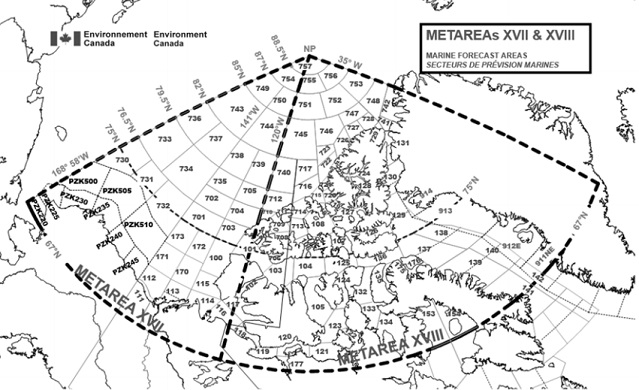
Text description of Figure 5-2 - Marine Forecast Areas: METAREAs XVII & XVIII
The map depicts the marine forecast zones within METAREAs XVII and XVIII. Each individual forecast zone has been assigned a unique number. The number corresponding to each forecast zone, along with the forecast zone name, is listed in one of the four tables below. These tables list which forecast zones are included in each METAREA forecast bulletin.
Figure 5-3 - Marine Forecast Areas: Northwestern METAREA IV
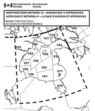
Text description of Figure 5-3 - Marine Forecast Areas: Northwestern METAREA IV
The map depicts the marine forecast zones within northwestern METAREA IV including Hudson Bay and Approaches. Each individual forecast zone has been assigned a unique number. The number corresponding to each forecast zone, along with the forecast zone name, is listed in the table below. The table lists which forecast zones are included in forecast bulletin for northwestern METAREA IV including Hudson Bay and Approaches.
5.9.6 Serviced Forecast Zones
Environment and Climate Change Canada provides marine weather warnings and forecast, wave height forecasts, and sea-ice conditions, to the following marine zones within METAREAs XVII, XVIII and northwestern sections of METAREA IV:
| Number | Area Name |
|---|---|
| 101 | McClure |
| 701 | CT4 |
| 702 | CU4 |
| 703 | South Prince Patrick |
| 704 | Prince Patrick |
| 705 | North Prince Patrick |
| 730 | CT1 |
| 731 | CT2 |
| 732 | CT3 |
| 733 | CU1 |
| 734 | CU2 |
| 735 | CU3 |
| 736 | CV1 |
| 737 | CV2 |
| 738 | CV3 |
| 739 | CV4 |
| 743 | CW1 |
| 744 | CW2 |
| 749 | CX1 |
| 750 | CX2 |
| 754 | CY1 |
| 757 | CZ1 |
| Number | Area Name |
|---|---|
| 100 | Prince Alfred |
| 101 | McClure |
| 111 | Yukon Coast |
| 112 | MacKenzie |
| 113 | Tuktoyaktuk |
| 114 | Baillie |
| 115 | Banks |
| 116 | Amundsen |
| 117 | Ulukhaktok |
| 170 | North Tuktoyaktuk |
| 171 | North MacKenzie |
| 172 | West Prince Alfred |
| 173 | Northwest Beaufort |
| 730 | CT1 |
| 731 | CT2 |
| 732 | CT3 |
| Number | Area Name |
|---|---|
| 101 | McClure |
| 106 | Byam |
| 107 | Queens |
| 108 | MacLean |
| 126 | Jones |
| 127 | Norwegian |
| 128 | Eureka |
| 129 | Clarence |
| 130 | Kane |
| 131 | Robeson |
| 707 | Fitzwilliam |
| 708 | Griper |
| 709 | Ballantyne |
| 710 | Brock |
| 711 | Wilkins |
| 712 | Borden |
| 713 | Hazen |
| 714 | Gustaf |
| 715 | Peary |
| 716 | South Ellef Ringnes |
| 717 | Ellef Ringnes |
| 718 | Hassel |
| 719 | Massey |
| 720 | South Sverdrup |
| 721 | North Sverdrup |
| 722 | South Axel Heiberg |
| 723 | Axel Heiberg |
| 724 | Greely |
| 725 | Nansen |
| 726 | Ellesmere |
| 727 | Ward Hunt |
| 728 | Bartlett |
| 729 | Alert |
| 740 | CV5 |
| 741 | CV6 |
| 742 | CV7 |
| 745 | CW3 |
| 746 | CW4 |
| 747 | CW5 |
| 748 | CW6 |
| 751 | CX3 |
| 752 | CX4 |
| 753 | CX5 |
| 755 | CY2 |
| 756 | CY3 |
| 757 | CZ1 |
| Number | Area Name |
|---|---|
| 101 | McClure |
| 102 | Prince of Wales |
| 103 | Melville |
| 104 | Rae |
| 105 | McClintock |
| 116 | Amundsen |
| 117 | Ulukhaktok |
| 118 | Dolphin |
| 119 | Coronation |
| 120 | Dease |
| 121 | Maud |
| 122 | St. Roch |
| 123 | Larsen |
| 124 | Peel |
| 125 | Barrow |
| 132 | Regent |
| 133 | Boothia |
| 134 | Committee |
| 135 | Admiralty |
| 136 | Lancaster |
| 137 | West Baffin |
| 138 | East Baffin |
| 139 | West Clyde |
| 140 | East Clyde |
| 141 | West Davis |
| 142 | East Davis |
| 153 | Igloolik |
| 154 | Prince Charles |
| 175 | Navy Board |
| 176 | Pond |
| 177 | Bathurst |
| 706 | Liddon |
| Number | Area Name |
|---|---|
| 911 | Attu |
| 912 | Uiffaq |
| 913 | Qimusseriarsuaq |
| 914 | Kiatak |
| Number | Area Name |
|---|---|
| 150 | Nottingham |
| 151 | West Foxe |
| 152 | East Foxe |
| 155 | Coats |
| 156 | Central |
| 157 | Arviat |
| 158 | Churchill |
| 159 | York |
| 160 | South-Central Hudson |
| 161 | South Hudson |
| 162 | Rankin |
| 163 | Baker |
| 164 | Roes Welcome |
| 310 | James Bay |
| 311 | Belcher |
| 312 | Puvirnituq |
Forecast service to U.S. waters within METAREA XVII is provided by the National Weather Service. Forecast service to Greenlandic waters within METAREA XVIII is provided by the Danish Meteorological Institute. Further information may be obtained by contacting these agencies directly.
Detailed information regarding the geographic locations and boundaries associated with the METAREAs forecast zones may be obtained by contacting the Meteorological Service of Canada at the following:
Telephone: 587-334-2892
Email: metarea17.18@ec.gc.ca
Additional information may be obtained by consulting the Joint Commission on Oceanography and Marine Meteorology (JCOMM) web site or by consulting the CCG Notices to Mariners (NOTMAR) web site.
5.9.7 METAREAs Forecast Transmission
During the navigation season, met MSI issued for METAREAs XVII and XVIII and northwestern sections of METAREA IV is broadcast via both Iridium SafetyCast and Inmarsat SafetyNET, noting the following:
- SafetyCast met MSI is broadcast directly into the GMDSS METAREA zones; and
- SafetyNET met MSI for sections of METAREA XVII and XVIII south of 75°N, and northwestern sections of METAREA IV, is broadcast over Inmarsat’s Asia-Pacific (APAC), Americas (AMER) or Atlantic Ocean Region-West (AOR-W) satellite network.
Scheduled broadcast times are:
| Broadcast Hour (UTC) | Met MSI Transmission Area | Transmitting Satellite | |
|---|---|---|---|
| 03:00 and 15:00 daily | METAREA XVII | Inmarsat (APAC & AMER) | Iridium |
| 03:00 and 15:00 daily | METAREA XVIII | Inmarsat (AMER & AOR-W) | Iridium |
| 03:00 and 15:00 daily | Northwestern METAREA IV | Inmarsat (AMER) | Iridium |
Met MSI for METAREAs XVII and XVIII will be transmitted using rectangular addressed messaging that encompasses waters comprising these two METAREAs until Inmarsat-C receivers or Mini-C terminals operating in Arctic waters have been updated to recognize the SafetyNET address code C3 = 17 and 18 for METAREAs XVII and XVIII respectively. Users should note that meteorological MSI received by their sat-C terminals may be labeled as navigational MSI.
Met MSI for the northwestern sections of METAREA IV is transmitted using rectangular addressed messaging that encompasses waters comprising Hudson Bay and Approaches. The SafetyNET address code for this rectangular area is C3 = 50n098w18030. Thus only those Inmarsat-C receivers aboard vessels navigating within the boundaries defined by this rectangular area will print out met MSI for the northwestern sections of METAREA IV.
During the navigation season met MSI for sections of METAREA XVII and XVIII north of 70° N is broadcast via High Frequency Narrow Band Direct Printing (HF NBDP) on 8416.5 kHz from the CCG MCTS Centre in Iqaluit NU. Scheduled broadcast times are 03:30 UTC and 15:30 UTC daily. Mariners should note that actual HF service provision dates will be announced by CCG Navigational Warning.
Mariners navigating northern or Arctic waters may also obtain METAREAs forecast bulletin via internet by accessing Environment and Climate Change Canada’s “Datamart” web page. However, users are cautioned that the internet is not part of the GMDSS MSI dissemination system and should never be relied upon as the only means to obtain the latest marine forecast and warning information. Access to the internet may be interrupted from time to time, or updates may be delayed. Mariners are advised to refer to the appropriate GMDSS marine communication systems such as Inmarsat-C SafetyNET, International NAVTEX, or HF NBDP for the latest information. When accessing Environment and Climate Change Canada’s Datamart web page please ensure the page you are viewing is updated and not from your web browser’s cache. If in doubt, use your web browser’s Refresh or Reload button to update the web page.
- The FQCN01 CWAO forecast for METAREA XVII north of 75° N
- The FICN01 CWIS ice bulletin for METAREA XVII north of 75° N
- The FQCN02 CWAO forecast for METAREA XVII south of 75°N
- FICN02 CWIS ice bulletin for METAREA XVII south of 75° N
- FZAK61 PAFG forecast coastal Arctic Alaska
- FZAK69 PAFG forecast offshore Arctic Alaska
- FQCN03 CWAO forecast for METAREA XVIII north of 75° N
- FICN03 CWIS ice bulletin for METAREA XVIII north of 75° N
- FQCN04 CWAO forecast for METAREA XVIII south of 75° N
- FICN04 CWIS ice bulletin for METAREA XVIII south of 75° N
- FICN07 CWIS ice bulletin for Greenlandic waters within METAREA XVIII
- FBDN51 EKMI warnings for Greenlandic waters within METAREA XVIII
- FQCN05 CWAO forecast for northwestern sections of METAREA IV
- FICN05 CWIS ice bulletin for northwestern sections of METAREA IV
5.10 Newfoundland and Labrador
5.10.1 Marine Weather Forecast Program
The Newfoundland and Labrador Weather Office (NLWO) in Gander provides year-round marine weather and wave height information for the waters around Newfoundland and Labrador out to approximately 250 nm and the waters of the Gulf of St. Lawrence, as well as for other specific bodies of water.
5.10.2 The Regular Program
This consists of a full 24 hours, 7 days a week weather watch, warning and amendment service provided by the Newfoundland and Labrador Weather Office in Gander. The regular marine forecast covers the period out to midnight of the following day (days 1 and 2). An extended marine wind outlook covering the next 3 days (days 3, 4, and 5) is also produced.
Wave height forecasts are produced twice a day and cover the period out to midnight of the following day.
| Forecast Name | Issue Time | Time Zone | Marine Region |
|---|---|---|---|
| Technical marine synopsis | 03:00, 10:00,15:30, 20:00 | NDT/NST | Newfoundland |
| 04:00, 09:30,16:00, 21:30 | NDT/NST | Labrador | |
| Marine forecast | 03:00, 10:00,15:30, 20:00 | NDT/NST | Newfoundland |
| 04:00, 09:30,16:00, 21:30 | NDT/NST | Labrador | |
| Marine weather statement | As needed | NDT/NST | Where needed |
| Wave height forecast | 06:00, 18:00 | NDT/NST | Newfoundland |
| 06:00, 18:00 | NDT/NST | Labrador | |
| Extended marine forecast | 03:00, 15:30 | NDT/NST | Newfoundland |
| 04:00, 16:00 | NDT/NST | Labrador |
| MCTS Centre | NAVTEX Transmitter | Header | Issue Time |
|---|---|---|---|
| Placentia/VCP | Robin Hood Bay | FQCN33 CYQX | 03:00, 06:00,10:00, 15:30, 18:00, 20:00 NDT/NST |
| Labrador/VOK | Cartwright | FQCN35 CYQX | 04:00, 06:00,10:00, 16:00, 18:00,21:30 NDT/NST |
Note: Refer to Part 2 for the MCTS broadcast schedule
5.10.3 Marine Weather Observations and Forecast Bulletins
As of November 15 2021, observations and forecast bulletins are available on MSC’s Hello Weather Service at 1-833-79HELLO (1-833-794-3556). Hello Weather has replaced MSC's Automated Telephone Answering Device (ATAD). Observations and forecast bulletins are also available on Weatheradio and the CCG’s continuous marine broadcast (CMB). Observations are updated hourly and include a series of coastal stations extending around the coast of Newfoundland and Labrador to the Maritimes and into the Gulf of St. Lawrence, as well as offshore buoys when available. Marine forecast bulletins are updated at regular intervals or whenever necessary.
5.10.4 Weatheradio Canada
Weatheradio is a public service designed to make weather information available over VHF or FM radio continuously. Weatheradio is dedicated to transmitting up to the minute weather reports and forecasts directly to all users including the marine community.
There is 1 main station in the Newfoundland and Labrador region:
| Station | Call Sign | Repeater |
|---|---|---|
| Gander | XLM 616 | 15 |
Frequencies in use: 162.400 MHz and 162.550 MHz.
Broadcasts can be received over most coastal areas of Newfoundland and southern Labrador, and include marine weather and ice warnings, regular marine and wave height forecasts, and synopses. Hourly updated observations from coastal stations and offshore buoys are all incorporated in the broadcast. For further information consult the Weatheradio website.
Figure 5-4 - Marine Forecast Areas Newfoundland and Labrador Waters
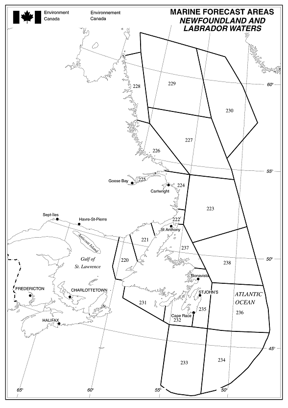
Text description of Figure 5-4 Marine Forecast Areas for Newfoundland and Labrador Waters
The map depicts the Newfoundland and Labrador marine forecast zones including the Labrador Sea, Grand Banks, and the coastal waters of Newfoundland and Labrador. Each individual forecast zone has been assigned a unique number. The number corresponding to each forecast zone, along with the forecast zone name, is listed in the Marine Forecast Areas table below for Newfoundland and Labrador Waters.
5.10.5 Marine Forecast Areas
| Number | AreaName |
|---|---|
| 220 | Gulf - Port au Port |
| 221 | Northeast Gulf |
| 222 | Strait of Belle Isle |
| 223 | Belle Isle Bank |
| 224 | South Labrador Coast |
| 225 | Lake Melville |
| 226 | Mid Labrador Coast |
| 227 | South Labrador Sea |
| 228 | North Labrador Coast |
| 229 | Northwest Labrador Sea |
| 230 | East Labrador Sea |
| 231 | Southwest Coast |
| 232 | South Coast |
| 233 | Southwestern Grand Banks |
| 234 | Southeastern Grand Banks |
| 235 | East Coast |
| 236 | Northern Grand Banks |
| 237 | Northeast Coast |
| 238 | Funk Island Bank |
Table 5-41 - Newfoundland and Labrador: Marine Weather Observations
Area Name
- Blanc Sablon
- Bonavista
- Burgeo
- Cape Race
- Cape Whittle
- Cartwright
- Chevery
- Daniel’s Harbour
- Englee
- Ferolle Pt.
- Grates Cove
- Happy Valley-Goose Bay
- Hopedale
- La Scie
- Makkovik
- Marticot Island
- Mary’s Harbour
- Nain
- Natashquan
- Pool’s Island
- Port aux Basques
- Sagona Island
- St John’s
- St. Anthony Airport
- Stephenville
- St. Lawrence
- Twillingate
- Winterland
- Wreckhouse
Observations will be broadcast only when available.
Hourly updated observations from coastal stations and offshore buoys may also be available on Weatheradio.
5.11 Maritimes Region
5.11.1 Marine Weather Forecast Program
The Atlantic Storm Prediction Centre (ASPC) in Dartmouth NS provides year-round marine weather and wave height information for the waters around the Maritimes to approximately 250 nm offshore, and the waters of the Gulf of St. Lawrence, as well as for other specific bodies of water.
5.11.2 The Regular Program
This consists of a full 24 hours, 7 days a week weather watch, warning and amendment service, including a detailed forecast for Halifax Harbour. The regular marine forecast covers the period out to midnight of the following day (days 1 and 2). An extended marine wind outlook covering the next 3 days (days 3, 4, and 5) is also produced.
Wave height forecasts are produced twice a day and cover the period out to midnight of the following day.
| Forecast Name | Issue Time | Time Zone | Marine Region |
|---|---|---|---|
| Technical marine synopsis | 03:00, 10:00, 15:30, 20:00 | ADT/AST | Maritimes |
| Marine forecast | 03:00, 10:00, 15:30, 20:00 | ADT/AST | Maritimes |
| 03:00, 10:00, 15:30, 20:00 | ADT/AST | Halifax Harbour and Approaches | |
| Recreational boating marine forecast | 03:00, 10:00, 15:30, 20:00 | ADT/AST | Bras d’Or Lakes |
| Marine weather statement | As needed | ADT/AST | Maritimes |
| Wave height forecast | 05:00, 17:00 | ADT/AST | Maritimes |
| Extended marine forecast | 03:00, 15:30 | ADT/AST | Maritimes |
| MCTS Centre | NAVTEX Transmitter | Header | Issue Time |
|---|---|---|---|
| Halifax/VCS | Chebogue | FQCN33 CWHX | 03:00, 05:00,10:00, 15:30, 17:00, 20:00 ADT/AST |
| Sydney/VCO | Port Caledonia | FQCN34 CWHX | 03:00, 05:00,10:00, 15:30, 17:00, 20:00 ADT/AST |
| FQCN34 CYQX | 03:00, 06:00,10:00, 15:30, 18:00, 20:00 NDT/NST |
Note:
Refer to Part 2 for the MCTS broadcast schedule
Marine Weather Warnings (refer to table 5-1 - Synoptic Warnings)
Note the following regional particularities:
| - | Warning Types | Comments |
|---|---|---|
| 1 | Strong wind warning | This warning is indicated in the forecast for coastal waters, Halifax Harbour and the Bras d’Or Lakes. Issued between April 15thand November 15th. |
5.11.3 The Recreational Program
The recreational program covers the waters of Bras d‘Or Lake in Cape Breton during the summer season (May 1 to October 31) and is provided as a service to recreational boaters. Recreational forecasts are issued 4 times a day.
5.11.4 Marine Weather Observations and Forecast Bulletins
As of November 15 2021, observations and forecast bulletins are available on MSC’s Hello Weather Service at 1-833-79HELLO (1-833-794-3556). Hello Weather has replaced MSC's Automated Telephone Answering Device (ATAD). Observations and forecast bulletins are also available on Weatheradio and the CCG’s continuous marine broadcast. Observations are updated hourly and include a series of coastal stations extending from the coast of Maine around the Maritimes and into the Gulf of St. Lawrence, as well as offshore buoys. Marine forecast bulletins are updated at regular intervals or whenever necessary.
5.11.5 Canadian Hurricane Centre
The Canadian Hurricane Centre (CHC) is co-located with the Atlantic Storm Prediction Centre. It becomes operational when a storm system of tropical origin enters or threatens to enter the designated response zone (north of 36ºN and west of 41ºW) within 3 days. The CHC may begin to issue bulletins on a semi-regular basis up to 5 days prior to the expected tropical weather event so as to maintain consistent and informative messaging on the storm, and also as a tool for early contingency planning for the relevant emergency response agencies.
During the CHC’s operational phase bulletins are issued at regular 6-hour intervals. These bulletins include information statements for Public and Media notification, and technical messages for use by MSC and Canadian Forces weather offices. Bulletins are issued at 3-hour intervals when the storm’s impacts are occurring within MSC’s forecast areas of responsibility, including offshore waters.
5.11.6 Weatheradio Canada
Weatheradio is a public service designed to make weather information available over VHF or FM radio continuously. Weatheradio is dedicated to transmitting up to the minute weather reports and forecasts directly to all users including the marine community.
There are 2 main stations in the Maritimes region:
| Stations | Call Sign | Repeaters |
|---|---|---|
| Moncton | XLM 466 | 8 |
| Halifax | XLK 473 | 14 |
Frequencies in use: 162.400 MHz, 162.475 MHz, 162.500 MHz and 162.550 MHz.
Broadcasts can be received over most coastal areas of New Brunswick, Nova Scotia and Prince Edward Island. Broadcasts include marine weather and ice warnings, and marine forecasts including wave heights, and synopses. Hourly updated observations from coastal stations and offshore buoys are all incorporated in the broadcast.
| WMO# | Name | LAT (deg) | LONG (deg) |
|---|---|---|---|
| 44137 | East Scotia Slope | 42.262 N | 61.998 W |
| 44139 | Banquereau | 44.240 N | 57.103 W |
| 44150 | La Have Bank | 42.505 N | 64.018 W |
| 44258 | Halifax Harbour Approaches | 44.502 N | 63.403 W |
| 44488Footnote * | East Chedabucto Bay | 45.445N | 60.954W |
| 44489Footnote * | West Chedabucto Bay | 45.487N | 61.141W |
| 44490Footnote * | West Bay of Fundy | 44.661N | 66.018W |
Figure 5-5 - Marine Forecast Areas: Maritimes Waters
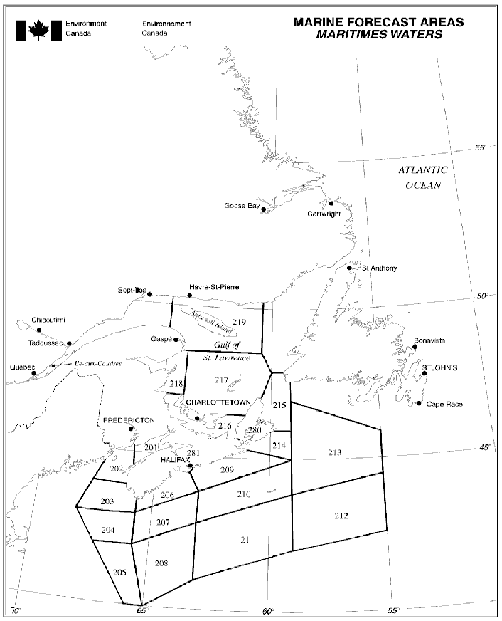
Text description of Figure 5-5 Marine Forecast Areas Maritimes Waters
The above map depicts the Maritimes marine forecast zones including the eastern Gulf of Maine, Scotian Slope waters, Cabot Strait and southeastern approaches, and the Gulf of St. Lawrence. Each individual forecast zone has been assigned a unique number. The number corresponding to each forecast zone, along with the forecast zone name, is listed in the Marine Forecast Areas table below for Maritime Waters.
5.11.7 Marine Forecast Areas
| Number | AreaName |
|---|---|
| 201 | Fundy |
| 202 | Grand Manan |
| 203 | Lurcher |
| 204 | Browns Bank |
| 205 | Georges Bank |
| 206 | Southwestern Shore |
| 207 | La Have Bank |
| 208 | West Scotian Slope |
| 209 | Eastern Shore |
| 210 | Sable Island |
| 211 | East Scotian Slope |
| 212 | Laurentian Fan |
| 213 | Banquereau |
| 214 | Fourchu |
| 215 | Cabot Strait |
| 216 | Northumberland Strait |
| 217 | Gulf - Magdalen |
| 218 | Chaleur - Miscou |
| 219 | Anticosti |
| 280 | Bras d’Or Lake |
| 281 | Halifax Harbour and Approaches |
Table 5-46 - Maritimes Region: Marine Weather Observations
Area Name
- Baccaro Point
- Bas Caraquet
- Beaver Island
- Brier Island
- Bouctouche
- Cap Chat
- Cap d’Espoir
- Caribou Point
- Charlo
- East Point
- Eskasoni
- Fundy Park
- Gaspé Airport
- Grand Étang
- Grand Manan
- Hart Island
- Havre-Saint-Pierre Airport
- Heath Point (Anticosti)
- Îles aux Perroquets
- Îles-de-la-Madeleine Airport
- Ingonish Beach
- Kouchibouguac
- Lunenburg
- Miscou Island
- Natashquan
- New Carlisle
- North Cape
- Parrsboro
- Pointe-des-Monts
- Point Lepreau
- Port aux Basques
- Port Menier (Anticosti)
- Rivière-la-Madeleine
- Sable Island
- Sept-Îles Airport
- St. Paul Island
- Summerside
- Sydney Airport
- Tracadie
- Western Head
- Wreckhouse
- Yarmouth Airport
Observations will be broadcast only when available.
Hourly updated observations from coastal stations and offshore buoys may also be available on Weatheradio.
5.12 Québec Region
5.12.1 Marine Weather Forecast Program
The program provides weather information for the St. Lawrence waterway and the Saguenay River, as well as for other specific lakes or navigable waterways.
5.12.2 The Regular Program
Area of coverage includes the St. Lawrence waterway between Cornwall*, Ontario, and Anticosti Island (65°W), and the navigable waterway of the Saguenay River between Saguenay and Tadoussac (see map areas 301-309). The program provides a full 24 hours, 7 days a week weather watch, warning and amendment service.
Regular forecasts are issued twice a day from the Québec Storm Prediction Centre in Montréal.
Time coverage: Year round *St. Lawrence Seaway portion (Cornwall to Montréal) in open season only.
Wave height forecasts are issued twice a day for marine areas 301, 302, 303 and 305.
| Forecast Name | Issue Time | Time Zone | Marine Region |
|---|---|---|---|
| Technical marine synopsis | 03:00, 15:00 | EDT/EST | St. Lawrence and Saguenay rivers |
| Marine forecast | 03:00, 15:00 | EDT/EST | St. Lawrence and Saguenay rivers |
| Marine weather statement | As needed | - | Where needed |
| Wave height forecast | 03:00, 15:00 | EDT/EST | St. Lawrence River |
| MAFOR | 03:00, 15:00 | EDT/EST | St. Lawrence and Saguenay rivers |
| Extended marine forecast | 06:00, 18:00 | EDT/EST | St. Lawrence and Saguenay rivers |
| MCTS Centre | NAVTEX Transmitter | Header | Issue Time |
|---|---|---|---|
| Les Escoumins/VCF | Moisie | FQCN37 CWUL | 03:00, 15:00 EDT/EST |
| FQCN37 CWHX | 03:00, 05:00, 10:00, 15:30, 17:00, 20:00 ADT/AST |
Note the following regional particularities with respect to the regular programs:
| - | Warning Types | Comments |
|---|---|---|
| 1 | Strong wind warning | Issued between May 1st and October 15th only. Regular program only. |
5.12.3 The Recreational Program
Area of coverage is for various inland lakes and navigable waterways (See map areas 380 to 386). The recreational program is active from May to October. Also provided is a full 24 hours, 7 days a week squall warning service during the summer months (refer to Table 5 2 - Localized Warnings / Watches and Marine Weather Advisory).
5.12.4 Marine Weather Observations and Forecast Bulletins
As of November 15 2021, observations and forecast bulletins are available on MSC’s Hello Weather Service at 1-833-79HELLO (1-833-794-3556). Hello Weather has replaced MSC's Automated Telephone Answering Device (ATAD). Observations and forecast bulletins are also available on Weatheradio and the CCG’s continuous marine broadcast (CMB). Observations are updated hourly and include a series of coastal stations along the St. Lawrence River. Marine forecast bulletins are updated at regular intervals or whenever necessary.
5.12.5 Weatheradio Canada
Weatheradio is a public service designed to make weather information available over VHF or FM radio continuously. Weatheradio is dedicated to transmitting up to the minute weather reports and forecasts directly to all users including the marine community. The table below lists all the Weatheradio stations under the responsibility of Environment and Climate Change Canada - Québec region broadcasting marine forecasts and weather reports, showing the stations and frequencies:
| Stations | Frequency (MHz) | Stations | Frequency (MHz) |
|---|---|---|---|
| Montréal | 162.550 | Prevert | 162.475 |
| Trois-Rivières | 162.400 | Rivière-au-Renard | 162.475 |
| Québec | 162.550 | Gaspé (Pudding Stone) Footnote * | 162.550 |
| Baie St-Paul | 162.400 | Carleton Footnote * | 162.500 |
| Grand-Fonds | 162.475 | Mingan Footnote * | 162.400 |
| Mont Valin | 162.550 | Kegaska Footnote * | 162.475 |
| Rimouski | 162.550 | Harrington Harbour Footnote * | 162.550 |
| St-Cléophas | 162.400 | Blanc-Sablon Footnote * | 162.400 |
| Sept-Îles (Pointe Noire) | 162.550 | Magdalen Islands Footnote * | 162.550 |
Figure 5-6 - Marine Forecast Areas: St-Lawrence and Saguenay Rivers
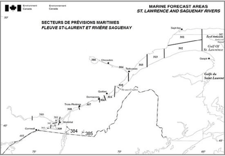
Text description of Figure 5-6 Marine forecast areas for the St Lawrence and Saguenay Rivers
This map depicts the St. Lawrence River marine forecast zones from the Ontario/Quebec border in the southwest to the mouth of the St. Lawrence River in the northeast. Also depicted are the marine forecast zones for the Saguenay River. Each individual forecast zone has been assigned a unique number. The number corresponding to each forecast zone, along with the forecast zone name, is listed in the Marine Forecast Areas table below for Quebec Waters.
5.12.6 Marine Forecast Areas
| St Lawrence/Saguenay | Major Inland Waters | ||
|---|---|---|---|
| Number | Area Name | Number | Area Name |
| 301 | Pointe-des-Monts to Anticosti - northern half | 307 | Trois-Rivières to Donnacona |
| 302 | Pointe-des-Monts to Anticosti - southern half | 308 | Montréal to Trois-Rivières |
| 313 | Pointe à Michel to Pointe-des-Monts | 309 | Cornwall to Montréal |
| 303 | Tadoussac to Pointe à Michel | 314 | Beauport to L'Isle-aux-Coudres |
| 304 | Saguenay to Tadoussac | 384 | Richelieu and Northern Lake Champlain |
| 305 | L’Isle-aux-Coudres to Tadoussac | 385 | Lake Memphrémagog - northern half |
| 306 | Donnacona to Beauport | 386 | Lake Saint-Jean |
Table 5-51 - Marine Weather Observations - St. Lawrence and Saguenay Rivers
- Baie-Comeau
- Beauport
- Cap Madeleine
- Cap Rouge
- Cap-Chat
- Île aux Grues
- Île d’Orléans (St François)
- Île Rouge
- La Pocatière
- Lac Saint-Pierre
- L’Assomption
- Mont-Joli
- Pointe Claveau
- Pointe-au-Père
- Pointe-de-l’Islet
- Pointe-des-Monts
- Pointe-Noire
- Sainte-Anne-de-Bellevue
- Sept-Îles
- St-Hubert Airport
- Trois-Rivières
Reports are broadcast only when available.
5.13 Great Lakes including St. Lawrence River to Cornwall
5.13.1 Marine Weather Forecast Program
The program provides marine weather information for the navigable waterway between Cornwall and Thunder Bay, and for other specific lakes or navigable waterways. Note that the program is applicable only to waters that lie on the Canadian side of the Canada-U.S. border.
5.13.2 The Regular Program
In addition to the Great Lakes, the area of coverage includes the waterway between Cornwall and Thunder Bay and is in effect year round except for the St. Lawrence Seaway portion where the service is only offered during the navigation season. The marine areas include: Lake Superior, Whitefish Bay, Lake Huron, Georgian Bay, Lake St. Clair, Lake Erie, Lake Ontario, and the St. Lawrence Seaway from Kingston to Cornwall. Note that the marine forecast applies to either the entire lake or the specified body of water comprising the forecast area of responsibility. The program provides a full 24 hours, 7 days a week weather watch, warning and amendment service. Synopses, regular marine and wave height forecasts are issued 3 times a day from the Ontario Storm Prediction Centre in Toronto.
| Forecast Name | Issue Time | Time Zone | Marine Region |
|---|---|---|---|
| Technical marine synopsis | 03:00, 10:30, 18:30 | EDT/EST | Great Lakes and the Ontario portion of the St. Lawrence River |
| Marine forecast | 03:00, 10:30, 18:30 | EDT/EST | Great Lakes and the Ontario portion of the St Lawrence River |
| Recreational boating marine forecast | 05:00, 11:30, 17:00 | EDT/EST | Lake of the Woods, Lake Nipigon, North Channel, Lake Nipissing, Lake Simcoe |
| Marine weather statement | As needed | - | Where needed |
| Wave height forecast | 03:00, 10:30, 18:30 | EDT/EST | Great Lakes only |
| MAFOR | 03:00, 10:30, 18:30 | EDT/EST | Great Lakes and the Ontario portion of the St. Lawrence River |
| Extended marine forecast | 03:00, 18:30 | EDT/EST | Great Lakes and the Ontario portion of the St. Lawrence River |
| MCTS Centre | NAVTEX Transmitter | Header | Issue Time |
|---|---|---|---|
| Prescott/VBR | Ferndale | FQCN38 CWTO | 03:00, 10:30, 18:30EDT/EST |
| Sarnia/VBE | Pass Lake | FQCN39 CWTO | 03:00, 10:30, 18:30EDT/EST |
Note:
Refer to Part 2 for the MCTS broadcast schedule
Marine Weather Warnings (refer to table 5-1 - Synoptic Warnings).
Note the following regional particularities with respect to the regular program:
| - | Warning Types | Comments |
|---|---|---|
| 1 | Strong wind warning | Issued April-November and applies to Canadian waters only |
5.13.3 The Recreational Program
Marine forecasts tailored to the needs of recreational boaters are issued during the recreational boating season 3 times a day for Lake Simcoe, Lake Nipissing, Lake of the Woods, the North Channel and Lake Nipigon. The season runs from May 1 to November 30.
5.13.4 Buoys
In order to complement the observational network, Environment and Climate Change Canada operates a network of buoys around the Great Lakes. This data becomes part of the collection of weather reports used to improve marine forecasting. Mariners are requested to use caution when approaching buoys as mooring chains are normally not detectable from a ship and can be damaged or even severed if there is contact, which could result in the buoy becoming adrift and a costly recovery of the platform. Please keep the regional Port Meteorological Officers informed of any incidents involving buoys.
| WMO# | Name | LAT (deg) | LONG (deg) |
|---|---|---|---|
| 45132 | Port Stanley | 42.467 N | 81.216 W |
| 45135 | Prince-Edward Pt | 43.784 N | 76.867 W |
| 45136 | Slate Island | 48.535 N | 86.953 W |
| 45137 | North Georgian Bay | 45.544 N | 81.015 W |
| 45139 | West Lake Ontario | 43.251 N | 79.534 W |
| 45142 | Port Colborne | 42.737 N | 79.290 W |
| 45143 | South Georgian Bay | 44.945 N | 80.627 W |
| 45147 | Lake St. Clair | 42.430 N | 82.683 W |
| 45148 | Lake of the Woods | 49.660 N | 94.519 W |
| 45149 | Southern Lake Huron (Bayfield) | 43.542 N | 82.075 W |
| 45151 | Lake Simcoe | 44.500 N | 79.368 W |
| 45152 | Lake Nipissing | 46.233 N | 79.716 W |
| 45154 | North Channel East | 46.051 N | 82.637 W |
| 45159 | NW Lake Ontario Ajax | 43.767 N | 78.984 W |
| WMO# | Name | LAT (deg) | LONG (deg) |
|---|---|---|---|
| 45001 | Mid-Superior | 48.064 N | 87.777 W |
| 45002 | Michigan N. | 45.344 N | 86.411 W |
| 45003 | N. Huron | 45.351 N | 82.840 W |
| 45004 | E. Superior | 47.584 N | 86.587 W |
| 45005 | W. Erie | 41.677 N | 82.398 W |
| 45006 | W. Superior | 47.335 N | 89.793 W |
| 45007 | S. Michigan | 42.675 N | 87.025 W |
| 45008 | S. Huron | 44.283 N | 82.416 W |
| 45012 | Lake Ontario | 43.619 N | 77.405 W |
| 45164 | W. Erie | 41.748 N | 81.698 W |
| 45180 | N. Superior | 48.034 N | 87.730 W |
| 45209 | S. Huron | 43.129N | 82.391W |
| 45211 | E. Superior | 46.973 N | 86.568 W |
5.13.5 Marine Weather Observations and Forecast Bulletins
As of November 15 2021, observations and forecast bulletins are available on MSC’s Hello Weather Service at 1-833-79HELLO (1-833-794-3556). Hello Weather has replaced MSC’s Automated Telephone Answering Device (ATAD).
5.13.6 Weatheradio Canada
Weatheradio in this region comprises a very comprehensive network of stations covering the Great Lakes area. Frequencies in use are: 162.400 MHz, 162.425 MHz, 162.450 MHz, 162.475 MHz, 162.500 MHz, 162.525 MHz, and 162.550 MHz. Broadcasts include marine warnings and forecasts as well as inland warnings and forecasts. Hourly updated observations from coastal stations and buoys are also incorporated in the broadcast.
Note: Weatheradio Canada automatically alerts users to severe weather warnings. If receivers are equipped with suitable alert devices they will emit a loud continuous tone and/or flashing light when a warning is issued. Detailed information about Weatheradio may be found online.
Figure 5-7 - Marine Forecast Areas: Great Lakes and St. Lawrence River

Text description of Figure 5-7 Marine forecast areas for the Great Lakes and St. Lawrence River
The above map depicts the marine forecast zones for the Canadian portion of the Great Lakes, major inland waters, and the St. Lawrence River, from the northwestern shores of Lake Superior in the west to the Ontario/Quebec border in the east. Each individual forecast zone has been assigned a unique number. The number corresponding to each forecast zone, along with the forecast zone name, is listed in the Marine Forecast Areas table below for Ontario Waters.
5.13.7 Marine Forecast Areas
| Commercial Shipping Waters | Major Inland Waters | ||
|---|---|---|---|
| Number | Area Name | Number | Area Name |
| 401 | Kingston to Cornwall | 481 | Lake Simcoe |
| 402 | Lake Ontario | 482 | Lake Nipissing |
| 403 | Lake Erie | 483 | Lake Nipigon |
| 404 | Lake St.-Clair | 484 | Lake of the Woods |
| 405 | Lake Huron | 485 | North Channel |
| 406 | Georgian Bay | - | - |
| 407 | Whitefish Bay | - | - |
| 408 | Lake Superior | - | - |
| Area Name | Reporting |
|---|---|
| Barrie | Reports from Duluth (Lake Superior) to DeTour Reef (Lake Huron) |
| Lake Simcoe ODAS buoy | Reports from Great Duck Island to Windsor |
| Lagoon City | Reports from Long Point to Port Colborne |
| Kingston | Reports from Kingston to Montréal |
| Alexandria Bay | Reports from Port Weller to Kingston |
| Massena | Reports from Sarnia to Port Colborne |
| Superior Shoals | Reports from Sault Ste Marie to Sarnia and Georgian Bay |
| Grenadier Islands | - |
| Montréal | - |
5.14 Pacific Coast
5.14.1 Marine Weather Forecast Program
The Pacific Storm Prediction Centre (PSPC) located in Vancouver, BC issues regular marine forecast and technical synopsis 4 times daily at the same time throughout the year. The forecasts are valid out to midnight of the following day. Additional products include a 3 to 5 day marine wind outlook and a wave height forecast issued twice daily.
| Forecast Name | Issue Time | Time Zone | Marine Region |
|---|---|---|---|
| Technical marine synopsis | 04:00, 10:30, 16:00, 21:30 | PDT/PST | Pacific waters |
| Marine forecast | 04:00, 10:30, 16:00, 21:30 | PDT/PST | Pacific waters |
| Marine weather statement | As needed | PDT/PST | Pacific waters |
| Wave height forecast | 04:00, 16:00 | PDT/PST | Pacific waters |
| Extended marine forecast | 04:00, 16:00 | PDT/PST | Pacific waters |
| MCTS Centre | NAVTEX Transmitter | Header | Issue Time |
|---|---|---|---|
| Prince Rupert/VAJ | Amphitrite Point | FQCN33 CWVR | 04:00, 10:30, 16:00, 21:30 PDT/PST |
| Digby Island | FQCN35 CWVR | 04:00, 10:30, 16:00, 21:30 PDT/PST |
Note:
Refer to Part 2 for the MCTS broadcast schedule
Marine Weather Warnings (refer to Table 5-1 - Synoptic Warnings).
Note the following regional particularities:
| - | Warning Types | Comments |
|---|---|---|
| 1 | Strong wind warning | Issued only from March 20 to Remembrance Day. Applies to the inner waters only: Queen Charlotte Strait, Johnstone Strait, Strait of Georgia, Howe Sound, Haro Strait and Strait of Juan de Fuca. |
5.14.2 Marine Weather Observations and Forecast Bulletins
Local weather observations are available for several stations including lighthouses, ocean buoys, automatic weather reporting stations and other stations of the regular weather network. The broadcast listing provides more information on available stations and broadcast times. Marine forecast bulletins are updated at regular intervals or whenever necessary. Starting November 15 2021, observations and forecast bulletins are available on MSC’s Hello Weather Service at 1-833-79HELLO (1-833-794-3556). Hello Weather has replaced MSC’s Automated Telephone Answering Device (ATAD). Observations and forecast bulletins are also available on Weatheradio and CCG’s continuous marine broadcast.
5.14.3 Weatheradio Canada
Weatheradio is a public service designed to make weather information available over VHF or FM radio continuously. Weatheradio is dedicated to transmitting up to the minute weather reports and forecasts directly to all users including the marine community.
Environment and Climate Change Canada Weatheradio operates four main stations serving Pacific region. These are:
| Stations | Call Sign | Frequency (MHz) | Note |
|---|---|---|---|
| Victoria (Saltspring) | XKK506 | 162.400 | Continuous broadcast |
| Burnaby | CGZ555 | 162.550 | Continuous broadcast |
| Texada | CGX451 | 162.550 | Continuous broadcast |
| Port Hardy (FM) | CBPD-FM | 103.700 | Continuous broadcast |
| Port Hardy | VFM839 | 162.525 | Continuous broadcast |
| Ucluelet | CIZ319 | 162.525 | Continuous broadcast |
| Port Alberni | VFM825 | 162.525 | Continuous broadcast |
| Prince Rupert | VXB571 | 162.525 | Continuous broadcast |
| Masset | CKK900 | 162.425 | Continuous broadcast |
| Sandspit | CYO869 | 162.500 | Continuous broadcast |
Further information regarding Weatheradio network can be obtained online.
| WMO# | Name | LAT (deg) | LONG (deg) |
|---|---|---|---|
| 46004 | Middle Nomad | 50.930 N | 136.095 W |
| 46036 | South Nomad | 48.355 N | 133.938 W |
| 46131 | Sentry Shoal | 49.906 N | 124.985 W |
| 46132 | South Brooks | 49.738 N | 127.931 W |
| 46145 | Central Dixon Entrance | 54.366 N | 132.323 W |
| 46146 | Halibut Bank | 49.340 N | 123.727 W |
| 46147 | South Moresby | 51.828 N | 131.225 W |
| 46181 | Nanakwa Shoal | 53.833 N | 128.831 W |
| 46183 | North Hecate Strait | 53.617 N | 131.105 W |
| 46184 | North Nomad | 53.915 N | 138.851 W |
| 46185 | South Hecate Strait | 52.425 N | 129.792 W |
| 46204 | West Sea Otter | 51.368 N | 128.750 W |
| 46205 | West Dixon Entrance | 54.185 N | 134.323 W |
| 46206 | La Perouse Bank | 48.835 N | 125.998 W |
| 46207 | East Dellwood | 50.874 N | 129.916 W |
| 46208 | West Moresby | 52.515 N | 132.692 W |
| 46303Footnote * | Georgia Strait | 49.025 N | 123.430 W |
| 46304Footnote * | English Bay | 49.302 N | 123.358 W |
Figure 5-8 - Marine forecast areas: Pacific waters
Text description of Figure 5-8 Marine forecast areas for Pacific waters
The above map on left depict the Ice information Areas for eastern Canadian waters, including the Tail of the Grand Banks, Flemish Cap, and the Southeast Labrador Sea. The map on right depicts the Ice information Areas for Basffin Bay and Davis Strait, located between Baffin island and Greenland. Similar to the marine forecast areas, each individual ice information area has been assigned a unique number.
5.14.4 Marine Forecast Areas
| Offshore | North Coast | South Coast | |||
|---|---|---|---|---|---|
| Area | Area Name | Area | Area Name | Area | Area Name |
| 001 | Explorer | 003 | Dixon Entrance West | 006 | West Coast Vancouver Island North |
| 002 | Bowie | 004 | West Coast Haida Gwaii | 007 | West Coast Vancouver Island South |
| - | - | 005 | Queen Charlotte Sound | 008 | Juan de Fuca Strait |
| - | - | 014 | Central Coast from McInnes Island to Pine Island | 009 | Haro Strait |
| - | - | 015 | Hecate Strait | 010 | Howe Sound |
| - | - | 016 | Dixon Entrance East | 011 | Strait of Georgia |
| - | - | 017 | Douglas Channel | 012 | Johnstone Strait |
| - | - | - | - | 013 | Queen Charlotte Strait |
Table 5-63 - Pacific Coast: Marine Weather Observations
- Addenbroke Island - L
- Ballenas Island – A
- Bella Bella - A
- Boat Bluff - L
- Bonilla Island – A, L
- Cape Beale - L
- Cape Flattery (USA) Footnote * - B
- Cape Mudge - L
- Cape Scott - L
- Cape St James - A
- Carmanah Point - L
- Cathedral Point - A
- Central Dixon Entrance - B
- Chatham Point - L
- Chrome Island - L
- Cumshewa Island - A
- Discovery Island - A
- Dryad Point - L
- East Dellwood - B
- East Point - A
- Egg Island - L
- Entrance Island – A, L
- Esquimalt Harbour - A
- Estevan Point – A, L
- Fanny Island - A
- Green Island - L
- Grey Islet - A
- Grief Point - A
- Halibut Bank - B
- Herbert Island - A
- Holland Rock - A
- Ivory Island - L
- Kelp Reef - A
- Kindakun Rocks - A
- La Perouse - B
- Langara Island - A, L
- Lennard Island - L
- Lucy Island - A
- McInnes Island - L
- Merry Island - L
- Middle Nomad - B
- Nanakwa Shoal - B
- Nootka - L
- North Hecate Strait - B
- North Nomad - B
- Pachena Point - L
- Pam Rocks - A
- Pine Island - L
- Point Atkinson - A
- Point Wilson (USA) Footnote * - L
- Port Angeles (USA) Footnote * - L
- Prince Rupert - A
- Pulteney Point - L
- Quatsino - L
- Race Rocks - A
- Rose Spit - A
- Sandheads - A
- Sartine Island - A
- Saturna Island - A
- Scarlett Point - L
- Sentry Shoal – B
- Sheringham Point - A
- Sisters Island - A
- Smith Island (USA) Footnote * - B
- Solander Island - A
- South Brooks - B
- South Hecate Strait - B
- South Moresby - B
- South Nomad - B
- Trial Island - L
- Triple Island - L
- Tsawwassen - L
- Tsawwassen Ferry- A
- Victoria Harbour – A
- Victoria/Gonzales Pt - A
- West Dixon Entrance - B
- West Moresby – B
- West Sea Otter – B
Lighthouse Reports (Type L), Automatic Reporting Stations (Type A), Ocean Buoys Reports (Type B)
5.15 Canadian Ice Service (CIS)
5.15.1 Ice Forecasts
Daily sea ice and lake ice forecasts are produced where there is marine activity. These bulletins describe the average ice concentration by marine area as well as the concentration of the thickest type of ice. If conditions are expected to be severe there will be an ice warning. The furthest extent of the edge of the ice for that region is provided using latitude and longitude coordinates.
The daily iceberg bulletin provides the estimated limit of all known icebergs using latitude and longitude coordinates and a general description of the number of icebergs for each marine area.
| Forecast Name | Issue Time | Time Zone | Marine Region |
|---|---|---|---|
| Iceberg bulletin | 18:30 | UTC | East Coast waters |
| Ice forecasts | 10:00 | EDT/EST | Western and Central Arctic |
| - | 11:00 | EDT/EST | Hudson and Foxe |
| - | 11:00 | EDT/EST | Eastern and Northern Arctic |
| - | 10:00 | EDT/EST | Gulf of St. Lawrence |
| - | 10:00 | EDT/EST | East Newfoundland and Labrador waters |
| - | 12:00 | EDT/EST | Great Lakes |
| MCTS Centre | NAVTEX Transmitter | Header | Issue Time |
|---|---|---|---|
| Placentia/VCP | Robin Hood Bay | FICN33 CWIS | 17:50 (W), 21:50 (S) UTC |
| Sydney/VCO | Port Caledonia | FICN34 CWIS | 22:10 UTC |
| Labrador/VOK | Cartwright | FICN35 CWIS | 23:20 UTC |
| Iqaluit/VFF | Iqaluit | FICN36 CWIS | 07:00, 19:00 UTC |
| Les Escoumins / VCF | Moisie | FICN37 CWIS | 14:50 UTC |
| Prescott/VBR | Ferndale | FICN38 CWIS | 00:40, 12:40 UTC |
| Sarnia/VBE | Pass Lake | FICN39 CWIS | 06:00, 18:00 UTC |
Note: Refer to Part 2 for the MCTS broadcast schedule
| - | Warning Name | Warning Criteria |
|---|---|---|
| 1 | Ice Pressure Warning | Reported or forecast strong ice pressure. |
| 2 | Rapid Closing of Coastal Leads Warning | Rapid closing of coastal leads is expected to occur. Leads are corridors of mainly ice-free water surrounded by pack ice. |
| 3 | Special Ice Warning | When one tenth or more of grey-white ice or older is expected to move into areas when that ice is not normally present, or forany unusual or significant ice event that may present a hazard to navigation. |
5.15.2 Ice Program
Ice forecasts are issued for daily, monthly and seasonal time scales.
5.15.3 Ice Reports or Observations
Ice reports from ships or aircraft are normally relayed through MCTS Centres for broadcast. These reports are all assimilated in the daily ice charts produced by CIS.
5.15.4 Ice Charts
Daily ice charts are produced in areas of active marine activity. Recent satellite imagery as well as computer model output are used as guidance to create the charts. The charts depict the forecast of the ice conditions at the valid time. The area covered by the chart depends on the time of the season and these charts are normally broadcast at times specified in tables below.
Satellite image analysis charts are produced for active marine areas when satellite is available. These represent the actual conditions at the time of the satellite image
Once a week, the CIS produces Regional ice charts. These charts are intended to be used as a planning tool and are available on the CIS webpages of Environment and Climate Change Canada’s website.
Users should note that these charts are not broadcast through MCTS Centres.
5.15.5 Weatheradio Canada
Ice forecasts and warnings are not broadcast via Weatheradio, however, mariners planning operations in waters impacted by hazardous ice conditions may obtain details regarding ice conditions by consulting the CIS webpages of Environment and Climate Change Canada’s website, or by contacting their regional MCTS Centre. Detailed ice information may also be obtained through consultation with an Environment and Climate Change Canada meteorologist using the “Weather One-on-One” 1-900 service at 1-900-565-5555. For cell phone users and credit card billing call 1-888-292-2222. User fees apply.
5.15.6 CIS Service to Marine Forecast Areas
The CIS issues ice bulletins and forecasts for most marine forecast areas with navigable waters, including Lake Michigan and the U.S. portion of the Great Lakes, whenever the presence of ice may hinder or otherwise pose a hazard to navigation. The areas for which ice bulletins and forecasts are issued correspond to the marine forecast areas as depicted in the Chapter 5 regional maps; refer to your region of interest for further information.
5.15.7 Daily Ice charts Broadcast
The following list describes daily ice charts produced to support marine activities which are available for broadcast from MCTS Sydney. All available charts can be transmitted or re-transmitted on request. Broadcast times are found in Part 2. The specific daily chart used to depict the ice conditions may vary depending on the location of the ice. For example, either Northeast or East Newfoundland charts may be provided, but not both at the same time.
| Ice Charts | Broadcast Site | Seasonal Availability |
|---|---|---|
| Iceberg limit | Sydney MCTS | Year round |
| Gulf of St. Lawrence | Sydney MCTS | Winter |
| Cabot Strait | Sydney MCTS | Winter |
| Northeast or East Newfoundland Waters | Sydney MCTS | Winter |
| Southeast Newfoundland Waters | Sydney MCTS | Winter |
| Newfoundland Coast | Sydney MCTS | Winter |
| Call Sign | Modulation | Index of Cooperation | Power | Frequencies (kHz) | Drum Speed |
|---|---|---|---|---|---|
| VCO | J3C (FM) | 576 | 5 KW | 4416, 6915.1 | 120 RPM |
For correct reception of this broadcast on WMO standard facsimile recorders requiring 2300 Hz for White and 1500 Hz for Black, 1900 Hz centre frequency, radio receivers should be tuned in the UPPER SIDEBAND MODE or USB: add 1.9 to the indicated USB frequencies for FSK frequencies.
5.15.8 Facsimile Broadcast
Upon authorized request from CCG, Transport Canada’s reconnaissance aircraft C-GCFR can transmit observed conditions via satellite fax. Vessels must make a request through the CCG to receive it.
- Date modified: